Gravity Field Discussion Forum
Dear ICGEM User,
Welcome to the Gravity Field Discussion Forum! This platform has been created to assist scientists, students, and anyone who is interested in using ICGEM service and its products.
Please post your questions, comments or critics here and ICGEM team will try to respond as soon as possible.
Moreover, other users are very welcome to actively join the discussion or answer the questions as well. Discussions of general interest can help many others and we make all inputs
available upon a confirmation by our system.
Before submitting your question, please take a look at our Frequently Asked Questions (FAQs) since your question might have already been asked and answered by our team.
Usage
Please type your name in the upper field, optionally your email address if you want to receive a message when your question is answered.
You can add your comment in the textarea, and then press
the send button.
Names are limited to 60 characters and the comment must not have less than 10 or more than 4000 characters,
otherwise it is rejected.
Your posting will appear on the top of the guest book listing after it is confirmed by our system.
You may also contact us per email.
| 410 |
Christoph Förste
|
| Friday, April 08. 2022 13:06:36 UTC |
| Answer on #408 |
| Dear Jun Weng,
sorry for our late answer on your question. But we habe no information about the status of EGM2020.
Regards
Christoph |
| 409 |
NDOUH HOUDOU
|
| Saturday, March 12. 2022 22:56:03 UTC |
| Besoin des données XGM2019E_2159 |
| Good evening sir where madam
Please I am NDOUH HOUDOU Students at the University of Yaoundé 1 in Cameroon in the department of physics option geophysics and I work in gravimetry
My concern is that I am working with the XGM2019E_2159 Field Model and I would like to have the data for my country Cameroon which is my study area, how do I do this please?
Bonsoir monsieur où madame
S'il vous plaît je suis NDOUH HOUDOU Etudiants à l'Université de Yaoundé 1 au Cameroun dans le département de physique option géophysique et je travaille en gravimétrie
Mon souci est que je travaille avec le modèle de terrain XGM2019E_2159 et j'aimerais avoir les données pour mon pays le Cameroun qui est ma zone d'étude, comment dois-je faire s'il vous plaît ? |
| 408 |
Jun Weng
|
| Friday, January 14. 2022 10:07:27 UTC |
| EGM2020 model |
| Why EGM2020 static gravitional field model not published yet? |
| 407 |
Yinglun Bai
|
| Thursday, January 06. 2022 11:36:03 UTC |
| There is something wrong with the calculation service |
| Dear ICGEM Team,
I want to download the gravity-earth data and geoid data of GOCO06s. The calculation service completed the geoid data calculation very quickly, and I successfully downloaded the data. However, the progress bar of gravity earth data is always 0%.
I don't know what went wrong. Here is the parameter in the calculation:
Longitude:-180°..180°
Latitude:-90°..90°
Gridstep:0.25°
Reference System:GRS80 |
| 406 |
Enock
|
| Wednesday, December 08. 2021 21:10:07 UTC |
| SHORY WAVE GRAVITY COMPONENTS |
| Hi ICGEM Team
Please guys i your assistants on the below questions
1. What are short wave gravity components?
2. What are sources of short wave gravity components ?
3. How can i review and analyse the short wave gravity components numerically from different sources.
4.why short wave and not long or medium wave of gravity components? |
| 405 |
sadik
|
| Sunday, November 28. 2021 14:23:58 UTC |
| mean elevation |
| dear ICGEM Team
how can i calculate the mean elevation of DTM2006. i can't find it in your calculation service |
| 404 |
FELAS
|
| Saturday, November 27. 2021 12:32:22 UTC |
| DILNALSYAH |
| please someone, i need help about file i get from regular grid, data i download from regular grid extension its gdf and eps, how to open the data? or what coding to extracting |
| 403 |
Serkan
|
| Wednesday, November 24. 2021 08:28:32 UTC |
| Answer to #402 |
| Dear Sinem,
First of all, thank you very much for your detailed answers. I re-run my calculation for about 98000 points and was able to get the results without any problems. Thanks again to you and Sven.
Best regards,
Serkan |
| 402 |
Sinem
|
| Tuesday, November 23. 2021 15:45:21 UTC |
| Answer to #397 |
| Dear Serkan,
1) In theory, we could introduce gravity_anomaly_cl also in the user-defined point calculations. At the moment, we use two different software for the regular grid and user-defined point calculations which are not identical. Efficiency was considered in the calculations. Therefore, not all the functionals were included in both (e.g. gravity_anomaly_cl, deflections of vertical). We may want to change this in the future.
2) Sven just investigated this problem. It seems that it was not the number of points, but the size of the input file was creating the error. We increased the possible size of the uploaded input file now. Could you please kindly re-run your calculation and let us know whether this solved the issue?
Best regards,
Sinem |
| 401 |
Abdallah saad
|
| Tuesday, November 23. 2021 12:39:46 UTC |
| appreciation to your great effort |
| thanks a lot |
| 400 |
Sinem
|
| Monday, November 22. 2021 13:34:38 UTC |
| Answer to #396 |
| Please refer to gravity_anomaly_cl and its definition in the technical report.
Best regards,
Sinem |
| 399 |
Sinem
|
| Monday, November 22. 2021 13:27:13 UTC |
| Answer to #395 |
| Dear Abdallah,
The development of such high resolution combined global gravity field models requires detailed investigations and therefore a great deal of effort. Processing, harmonizing, and combining the collected data with satellite data and other data is not an easy task. We know that there have been continuing research on this subject and we plan to make new higher resolution models available at ICGEM in the future. By the way, you might want to take a look at model #176 in the Static Models list and its reference to follow up with one of the recent studies.
Best regards,
Sinem |
| 398 |
Sinem
|
| Monday, November 22. 2021 13:17:49 UTC |
| Answer to #394 |
| Dear Abdallah,
This question does not have a short answer.
I could only recommend you to read different studies in the literature.
Nevertheless, you can start with reviewing our evaluation sections, in spectral domain and w.r.t. GNSS/Levelling.
There are also various studies, including Newton's Bulletins and Pavlis et al. 2012 (https://agupubs.onlinelibrary.wiley.com/doi/full/10.1029/2011JB008916).
Best regards,
Sinem |
| 397 |
Serkan
|
| Sunday, November 14. 2021 11:23:54 UTC |
| General questions |
| Dear ICGEM Team,
First of all, I wish you good work. I have a few questions that I am curious about, I would be happy if you answer them.
1) Why can't we calculate free-air gravity anomalies (gravity_anomaly_cl) from the "user-defined points" tab? Is there a special reason?
2) In the "user-defined points" tab, the number of points I calculated in the past was around 90000, but now I can't even calculate half of it. Did you set this restriction or is there a point I missed?
Best Regards,
Serkan |
| 396 |
Abdallah Saad
|
| Saturday, November 13. 2021 12:42:55 UTC |
| free air anomalies |
| why do not you have free air anomalies in your global models products? |
| 395 |
Abdallah Saad
|
| Saturday, November 13. 2021 12:38:20 UTC |
| degree and order (resolution) of the models |
| why, until now, there is no global gravity model with degree and order more than 2190 although the available input data became more and more? |
| 394 |
Abdallah Saad
|
| Saturday, November 13. 2021 08:04:57 UTC |
| accuracy of global geopotential models |
| is there a relation between the degree and order of a global model and its accuracy? |
| 393 |
Sinem
|
| Wednesday, November 10. 2021 17:26:10 UTC |
| Answer to #390 |
| Dear Reza,
Grid calculation of deflections of vertical is in our to do list. Unfortunately, I cannot promise when it will be introduced but we have this in mind.
The background software for grid and user-defined point calculations are different. That is why we cannot introduce it in the list at the moment.
Best regards,
Sinem |
| 392 |
Sinem
|
| Wednesday, November 10. 2021 17:20:43 UTC |
| General/questions |
| Dear all,
Some of the questions received during the last year have been answered via e-mails.
The ones that have not been answered below or via e-mail:
1- Require user to study literature. Unfortunately, ICGEM (team)'s experience is limited and we do not have all the answers.
2- Are forwarded to the email list with the hope that some experts and other users may be able to answer. Please feel free to exchange ideas, and transfer knowledge.
Thank you for your understanding.
Best regards,
Sinem |
| 391 |
andrew_klikunov
|
| Friday, November 05. 2021 19:18:26 UTC |
| Krasovsky ellipsoid |
| Hello! I am trying to calculate the height of a quasigeoid above the surface of a Krasovsky ellipsoid. Initial data:
GM = 3.98613140504704e + 14
U0 = 62637777.77
a = 6378245 m
flattening = 298.3
omega = 7.292115 * 10-5
I use the EGM2008 model. After calculating the height of the quasigeoid, I get an incorrect result at the control point. Let me explain. The origin of the coordinate system is located in Pulkovo (St. Petersburg). The height of the geoid and quasigeoid at this point is equal to zero (assigned directively when setting the datum). When calculating, the height of the geoid / quasigeoid is more than 100 meters, which is completely wrong. What is the reason for these errors? Is it that the center of Krasovsky's ellipsoid does not coincide with the center of mass of the Earth? But, I calculated the coordinates of the XYZ center of the Krasovsky ellipsoid relative to the earth's ellipsoid. How can I enter these coordinates? Or do I need to transform the coefficients of the gravitational field model? This can be done, but I do not know how to calculate the coefficients of the model, which are responsible for the position of the center of the elliposoid (С11, S11 and so on, shifts). I have looked at the frequently asked questions, but I have not found the answers to these questions, unfortunately. Maybe you can help with this task? |
| 390 |
Reza
|
| Wednesday, October 20. 2021 09:27:51 UTC |
| deflection of vertical |
| Hello ICGEM Team,
Would you please make it possible to your users to get the deflection of vertical and its components on the regular grid? on the user-defined points menu, I can get them but on the regular grids menu, these functionals don't exist.
Best Regards
Reza |
| 389 |
Enock
|
| Sunday, October 03. 2021 12:57:23 UTC |
| bathymetric map |
| Hi ICGEM team
I'm mr. Enock ,a third year student at Ardhi university,,kindly am asking how the bathymetric map can be produced by using continuous gravity data.Please helping me you allon this topic because am expecting to do it in my dissertation as well as the sources
kindly
upcoming Geodesist |
| 388 |
Oyekeye, Olumide Israel
|
| Thursday, September 23. 2021 11:08:59 UTC |
| Extracting result after calculation |
| Please kindly tell me how to retrieve the result of my computation on this platform. I input my latitude, longitude and height requesting to get the bouguer anomaly of the point, after the software calculated i could not see the result anywhere, nor was it displayed |
| 387 |
Ayoub
|
| Tuesday, August 31. 2021 20:17:37 UTC |
| Gravity SH time series with different truncations! |
| Hello,
I recently obtained the GFZ Gravity Spherical Harmonic files from the FTP server. I see however that, the solutions are not truncated in a same degree/order maximal. Meaning that, they include different truncations, e.g.: in 60, 96 and 180. The same issue for the solutions from JPL and SCR solutions exists.
I would like to know what the reason is for the difference in truncation of successive solutions. And more important, how these time series could be logical and comparable actually, if they are not truncated in the same d/o; unless the user limits the process in a specific d/o, for all files.
Thank you very much for giving any response, and letting me be cleared on this issue by any explanations or through references. |
| 386 |
Heba
|
| Monday, July 05. 2021 14:33:32 UTC |
| Resolution of XGM2019e_2159 Model |
| Dear ICGEM Team,
What is the highest resolution of XGM2019e_2159 Model with function gravity anamoly Bouguer? and also how can I find the reference paper of this model?
All the best,
Heba |
| 385 |
Nina
|
| Wednesday, June 23. 2021 08:58:59 UTC |
| Gentle-cut |
| Dear Administrator,
My name is Nina, i am Bachelor degree student.
I have any question,
i have read gentlegut_engl.pdf but i still dont understand yet.
what is functional of truncating, oscillation, start genlte cut and Max Degree?
what is the effect on the gravity anomaly?
Thank you in advance |
| 384 |
Kurosh
|
| Friday, June 18. 2021 11:38:52 UTC |
| second r-derivatives of Mars and Venus |
| Dear ICGEM Team
I appreciated your effort to facilitate working in the area of geoscience.
As for the second r_derivative of gravity of Mars and venus. The resultant maps in low altitudes (h=0) seem to be noisy with lots of tiny fluctuations of the field.what is the reason for that? |
| 383 |
Nina
|
| Tuesday, June 15. 2021 03:25:47 UTC |
| Gravity Field |
| How to visualisation gravity field (EGM2008 & EIGEN6C4) at the ArcMap Software? |
| 382 |
Heba
|
| Monday, May 10. 2021 08:23:04 UTC |
| How to calculate your model? |
| Dear ICGEM Team,
I am a Ph. D. student and am new to gravity method. I am advised to use your service to have a background model in mind before going through developing mine but I don't understand actually how to use your model. I specified area and downloaded a file XGM2019e_2159.gfc but I don't know what to do next. how I could access this file and whether it is already calculated or I need to calculate it by special software and on which basis I choose the degrees and steps. Could you help me to understand how to get started?
Thanks in advance.
All the best,
Heba |
| 381 |
Julian
|
| Tuesday, April 20. 2021 13:37:53 UTC |
| Vertical deflection inside mass |
| Dear ICGEM team,
When computing vertical deflection from a list of points with latitude, longitude and height, is the point considered as inside mass if height is below ropographical surface ? If so how is carried out the correction ?
Many thanks,
Julien |
| 380 |
Nikhil
|
| Monday, April 05. 2021 10:51:40 UTC |
| Spatial Resolution |
| How to get spatial resolution of EIGEN 6C4 gravity model in ICGEM? |
| 379 |
Daniel
|
| Sunday, April 04. 2021 00:52:16 UTC |
| What is the best for regional geology in Brazil? |
| Can you help me??
What is the best satellyte to use gravimetry data in South part of Brazil?
I work with regional geology so, it will be really useful the most detailed one to identify shear zones and basins.
I read that GO_CONS_GCF_ grace and GOCE are very used very often in papers.
Can you give me your sugestion??
Thanks |
| 378 |
Spyros
|
| Friday, February 19. 2021 16:40:45 UTC |
| calculation problem |
| Dear ICGEM Team,
Is there any problem with the user-defined calculation procedure? It doesn't work.
It is a great tool and the last month I have faced several problems. Now it doesn't even open the calculation tab.
Can you help by looking it and fixing?
Thank you
Spyros |
| 377 |
Satish
|
| Wednesday, February 10. 2021 09:27:01 UTC |
| Hello,
Thank you for the excellent scientific service to the geodetic community across the world.
I have been using the Calculation Service for generating gravity anomalies near the earthquake epicenters. I have observed that the gravity anomalies are in the range of mgal, however the research articles from different authors always obtained the gravity signatures in the range of ugal(micro gal). What could be the reason? ( I am using the Model form Series - CSR RL05 data for calculation of gravity anomaly).
Request to provide some knowledge on this.
Thank you.
SATISH. |
| 376 |
Bing Cheng
|
| Sunday, January 17. 2021 03:12:02 UTC |
| Dear ICGEM Team,
Thank you very much for your great work. I am a geodetic engineer from China. I need to calculate the height anomaly for transformation from ellipsoidal height to normal height. Here, the height anomaly I mean the distance from the ellipsoid to the quasi-geoid. Then, I have used the Calculation Service, including "Regular grids" and "User-defined points" tools for height anomaly. I met some problems in the process and would like to consult you. (1)The “height anomaly” in the Calculation Service mean the same thing with “height anomaly” what I need? (2) I have checked the accuracy of some points using EGM2008(using your Calculation Service) in Chengdu plain, Sichuan China, errors is more than 40 centimeters, worse than the Eigen-6c4, XGM2019e.So, I don't know if this computing service for EGM2008 is reliable? (3)When I used the exact same latitude, longitude and height for height anomaly calculating using "Regular grids" and "User-defined points" tools, I actually got different results, and the difference was relatively large, it's RMS was up to 7.3cm(88,688 points in Sichuan were participated in statistics).(4)There was a huge difference in calculation speed, "User-defined points" is really inefficiently.(5)The resulting output file format is inconsistent. (6)Therefore, I would like to ask if the two tools use different background programs? If so, which is more reliable?
I am very sorry for my poor English and theoretical knowledge.
Best regards.
Bing Cheng. |
| 375 |
Ecem
|
| Tuesday, January 12. 2021 19:22:26 UTC |
| Dear ICGEM editor,
I uploaded the .txt file. But when I click "start computation" it doesn't give me any results. It redirects me back to the same page (Calculation of Gravity Field Functionals on User-Defined Points). Will you please help me out? |
| 374 |
MASOOD ALAM
|
| Monday, January 11. 2021 12:41:06 UTC |
| Hello there! Myself Masood Alam working in Geodynamics.. I want to see Gravity variation in time over a time gap of more than 1 or 2 years.
Question 1: Can I use static models for this purpose for getting satisfactory spatial resolution as well as temporal resolution?
Question 2: Are the new static models are computed by integrating the new data with old static models?
Thank you for providing us these valuable data and knowledge. Please reply. |
| 373 |
Kyamulesire Bruno
|
| Friday, December 18. 2020 18:45:13 UTC |
| I need serious help. After downloading the models (GECO, Xgm2019, xgm2016),how can i turn them into ggf files to suit my applications.What do i do for the spherical harmonics? My applications are based on GRS80 ellipsoid & i need ggf files. Thank You |
| 372 |
Михаил
|
| Sunday, December 13. 2020 13:46:22 UTC |
| Hello for everyone! I am working on my dissertation so I have used the tools from this site to calculate a geopotential in some points above the earth ellipsoid. I've got some results and have compared them with some I've got using my own tools. So there is a question: how the height above the ellipsoid is considered to calculate the distance between the center of the ellipsoid and the point where I want to calculate the geopotential because the value of the potential depends on this. |
| 371 |
Olessya
|
| Sunday, November 01. 2020 13:29:37 UTC |
| Hello there! My name is Olesya! Please tell me! I am writing a research paper "Research on methods for creating a quasigeoid height model". I have GPS observation data and grade 2 leveling marks. How do I create a model on this site? Sorry, I translate into English using Yandex translator) Thanks! |
| 370 |
Sinem
|
| Wednesday, October 28. 2020 07:14:02 UTC |
| Dear Riche,
Text editors (e.g. Notepad++) would do the work, so there is no requirement for a special software.
Regards,
Sinem |
| 369 |
Loken
|
| Wednesday, October 28. 2020 02:39:40 UTC |
| For online computing grid data, the format is gdf, which is not the nc format that I am familiar with. Is there a special software to process this format, or to convert its format? Thank you! |
| 368 |
Riche
|
| Tuesday, October 27. 2020 01:36:13 UTC |
| Sorry for the ambiguity in the description of the problem. I have solved this problem. For grid data calculated online, the format is gdf. Does the processing of this format require special software? It does not look like our common format? kind regards! |
| 367 |
Christoph Förste
|
| Monday, October 26. 2020 11:08:23 UTC |
| Dear Riche,
your question is not clear for me. Global gravity models like the GOCE and GRACE models are usually given in terms of spherical harmonics without any associated reference ellipsoid. A reference ellipsoid is only needed for computation of functionals based on spherical harmonics like geoid undulation or gravity anomaly.
You also asked about the permanent tidal system. This regards the spherical harmonic coefficient C20. For the various GOCE and GRACE models, the applied tide system may be different but it’s usually clearly specified in the header of the respective spherical harmonic data set. For instance, GFZ’s GOCE models are usually given in the tide free system while UTCSR’s GRACE models are given in zero tide. More detals are given i.e. in the GOCE standards document:
https://earth.esa.int/web/guest/document-library/browse-document-library/-/article/goce-high-level-processing-facility-goce-standards-5720
Regards
Christoph |
| 366 |
Sinem
|
| Monday, October 26. 2020 07:48:53 UTC |
| Dear Abdulmumin Lukman,
I was able to run the calculation service for the last two in the list. Could you please specify what kind of error do you get?
Best regards,
Sinem |
| 365 |
Riche
|
| Friday, October 23. 2020 02:50:14 UTC |
| Is the reference ellipsoid used in GOCE's static gravity model and Grace's static gravity model the same as the tidal system? I know that GOCE uses the T/P ellipsoid and the average tide system. I have not found this information about Grace. . thanks for your help! |
| 364 |
Abdulmumin Lukman
|
| Monday, October 19. 2020 10:06:08 UTC |
| In the latest model (i.e XGM2019e_2159), one cannot use the calculation service on the last two modules. Is there a way to that?
thanks |
| 363 |
Sinem
|
| Thursday, October 15. 2020 08:33:54 UTC |
| Dear Alexandre (#357),
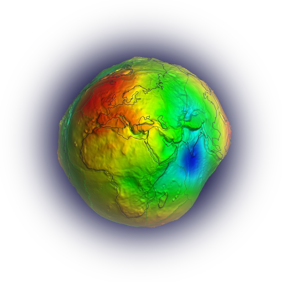
In the 3D visualisation, we subtract the WGS84 coefficient C(2,0) in fact (and not the exact ellipsoid). One could subtract C(2,0), C(4,0),…C(10,0), but this would not be visible in such a visualisation.
Maybe it is worth mentioning that the software used in the computation of visualised values (in 3D visualisation) is different than what is used for the grid (or user-defined point) calculations. Our aim is to provide a visualisation tool (for the geoid or gravity anomaly) as informative as possible in a fast way.
Hope it helps.
Best regards,
Sinem |
| 362 |
Sinem
|
| Thursday, October 15. 2020 08:24:12 UTC |
| Dear Isaac (#352),
Thank you for your question.
1) ETOPO1 was downloaded from https://www.ngdc.noaa.gov/mgg/global/. Therefore, we did not calculate nor change anything in this model. However, we calculated the representation in terms of spherical harmonic coefficients if this is what you meant.
2) As you can imagine ETOPO1 is a relief model that comes with the topography and bathymetry information. The vertical datum is "sea level" but I think for more precise information on the (mean) sea level concept you may want to refer to the original provider.
Maybe a quick explanation on the use of ETOPO1: Wherever the topography is needed for the position of calculation point, it is interpolated from the ETOPO1 grid (topography_grd). Not all but most of the functionals require this information.
For the Bouguer gravity anomalies, the heights for the Bouguer reduction is calculated from the spherical harmonic model of ETOPO1 (topography_shm). In our calculations, the same expansion degree as for the gravitational field is taken (l_max) since it is commonly practised that the effect of the topography should not include shorter wavelength information than the gravity field itself.
Hope it helps.
Best regards,
Sinem |
| 361 |
Abolade Olawuyi
|
| Tuesday, October 06. 2020 10:48:53 UTC |
| Hi,
I want to get the geoid value for some selected points and I try to upload but I couldn't go beyond that.
Its not bringing any result for the points and even its not processing.
I need help on the type of format the website program can accept, csv, txt, xlxs etc |
| 360 |
Alexandre
|
| Monday, October 05. 2020 14:36:42 UTC |
| Hi,
In 3d visualization, what is in subtrahend the "ellipsoid (c(20))"? And, is there a reason to not have the WGS84 as an option?
Thanks.
Alexandre |
| 359 |
Christoph Förste
|
| Monday, September 28. 2020 14:13:42 UTC |
| Dear Abdelrahim (#350),
The spherical harmonic coefficients of the global gravity field models stored here at ICGEM are mainly outcome of least square adjustment. This estimation approach yields errors along with the coefficients. These errors are called “formal” errors. Like in least square adjustment in general, the values of the estimated (i.e. formal) errors are strongly dependent on the inherent stochastic model(s) and may be physically too optimistic. Therefore, sometimes the errors are scaled towards the physical reality based on evaluation by using external data. After such a scaling the errors are called “calibrated”.
According to the ICGEM format definition the case “non-calibrated” should not occur. The case “no” is possible. That means the spherical harmonic coefficients are given without errors resp. zero errors. Another possible case is “calibrated_and_formal”. That means that only parts of the errors are calibrated. In this case the details should be given in comments op top of the header or in related literature.
The meaning of full normalization resp. non-full normalization of spherical harmonic coefficients is well explained in many standard textbooks about Geophysics und Geodesy like Hofmann-Wellenhof, B. & Moritz, H., Physical Geodesy, Springer, 2005
Christoph |
| 358 |
Sinem
|
| Monday, September 28. 2020 08:03:07 UTC |
| Dear Lisa,
Thank you for your question and sorry for responding late. We are only now being able to catch up with the questions.
I am sure there are experts in the forum who can help you better, but I can imagine negative EWH indicating decline in ground water and vice versa. What is the ambiguity? Are you receiving different indications than expected?
Best regards,
Sinem |
| 357 |
Sinem
|
| Monday, September 28. 2020 07:47:51 UTC |
| Dear Huang (#348),
GSM refers to monthly GRACE/GRACE-FO series, whereas EGM (Earth Gravitational Model) refers to mean (static) Earth gravity field model. You may also refer to the FAQ under Documentation (e.g. questions 2, 7, 11).
Best regards,
Sinem |
| 356 |
Sinem
|
| Monday, September 28. 2020 07:36:16 UTC |
| Dear Shaokai (#347),
Thank you for using our service and your question.
dV_ELL_Earth2014_5480 is a topographic gravity field model. It represents the gravitational potential generated by the attraction of the Earth's topographic masses. Therefore, I believe this is different than what you would like to use in your calculations. In our service, we offer ETOPO-1 for topography related calculations. You could also extract information from ETOPO via the Calculation Service > Regular grids.
In the "Model selection" part, you could choose "Topography" and can extract the topography information based on either topography_shm (from the representation in spherical harmonics) or topography_grd (directly from the gridded ETOPO-1). This would provide you the elevation information in the area of your interest.
Hope this helps.
Best regards,
Sinem |
| 355 |
Isaac O. Apeh
|
| Sunday, September 27. 2020 19:39:20 UTC |
| Dear Sinem
Thank you for your prompt responses to questions.
I am a bit confused (may be the definitions are not distinct enough) about these two definitions of the topographic heights for calculating Bouguer gravity anomalies: (i) in the topography model ETOPO1, which coefficients were used-that of the DTM2006 or was it “newly” calculated? (ii) which topographic heights were calculated from the spherical harmonic model DTM2006 and for which purpose? Could you please give more explanation on them
(1) Topography_shm
For calculating the geoid heights from the height anomalies and for calculating the Bouguer gravity anomalies a spherical harmonic model of the Earth's topography is used, and we offer the possibility to calculate this topography separately (eq. 115 of STR09/02). The model is the spherical harmonic expansion of the (1′ × 1′) - grid of ETOPO1 (version: Ice Surface). The values are calculated, as the model itself, with respect to the geoid.
(2) Gravity_anomaly_bg
The (simple) Bouguer gravity anomaly is defined by the classical gravity anomaly minus the attraction of the Bouguer plate. Here it will be calculated by the spherical approximation of the classical gravity anomaly minus 2πGρH (eqs. 107 and 126 ofSTR09/02). The topographic heights H(λ,φ) are calculated from the spherical harmonic model DTM2006 used up to the same maximum degree as the gravity field model |
| 354 |
Oloyede Paul
|
| Thursday, September 17. 2020 00:05:24 UTC |
| Hello, please how do I determine the anomaly for a particular point location. I need help urgently on this.
Is there any official website, where so video tutorial of the website are. |
| 353 |
Abdelrahim Ruby
|
| Sunday, August 30. 2020 13:11:27 UTC |
| Hello ICGEM, I am Abdelrahim from Wuhan University, China.
How to read the EGM gfc-files and what does it mean the errors of the geopotential models are formal, calibrate, and non-calibrate. Also, what does it mean the norm is fully normalized or non-fully normalized?
For example:
modelname TUM-1S
earth_gravity_constant 3.98600436e+14
radius 6378137.0
max_degree 60
errors formal
norm fully_normalized
tide_system tide_free
----------------------------------------------------------
modelname GGM03S
earth_gravity_constant 0.3986004415E+15
radius 0.6378136300E+07
max_degree 180
errors calibrated
norm fully_normalized
tide_system zero_tide
Kindly, inform me with receipt
Thanks in advance. |
| 352 |
Lisa Sanga
|
| Thursday, August 20. 2020 17:28:04 UTC |
| Dear Sinem
I have faced an ambiguity in some issues related to EWH.
I have subtracted the GRACE-FO and GLDAS datasets so as to remain with Groundwater. What I have remained with are equivalent water heights groundwater variations.
My question is..what does it mean by positive and negative values of EWH. And how can you relate with water on the ground? Does it mean that the higher the value of EWH, the more the large amount of water underground?
With best regards
Lisa |
| 351 |
Rahul G
|
| Tuesday, August 11. 2020 10:27:20 UTC |
| Dear ICGEM Editor,
Could you please let me know how to calculate GOCE gradients (e.g. VXX, VXY, VXZ, VYY, VYZ, etc.) using this platform?
Kind regards, |
| 350 |
Huang
|
| Thursday, August 06. 2020 03:55:13 UTC |
| what is the difference between GSM and EGM? |
| 349 |
shaokai
|
| Tuesday, August 04. 2020 07:32:15 UTC |
| This is a wonderful website from which I learned a lot! Now, I am trying to compute the local geoid of my institute in beijing. In my understanding, I should make use of the topography information H(LAMBDA,PHI), but which model should I use? I have tried the dvelldVELLEarth20145480 model, the fluctuation of the topography is from -1.9573km to -3.5444km, which is obviously incorrect. I dont know where I was WRONG. Can you help me? Thank you!
Best regards. |
| 348 |
Sinem
|
| Friday, July 17. 2020 08:50:45 UTC |
| Dear Ke Wang,
Thank you for your message and sorry for the inconvenience.
The topography information (ETOPO) used in our calculations is also represented in terms of spherical harmonic coefficients and it is expanded only up to 2250.
Therefore, if the functional requires the use of such information with a model expanded up to degree 5400 then it will not complete the calculation. That is why we did not include XGM2019e_5540 option in the calculation service at the moment.
This is in our to do list and we hope we could update the topography model this year.
Best regards,
Sinem |
| 347 |
KE WANG
|
| Friday, July 17. 2020 08:14:51 UTC |
| Dear SINEM,
Why xgm2019e_ 5400 model can not be calculated online in the "user-defined points"? |
| 346 |
BENDIAB FATHI
|
| Thursday, July 02. 2020 09:24:13 UTC |
| Dear SINEM,
Thank you for your interest in our messages.
Along with its, there is no worry for small delays, especially when it comes to updating.
Good luck.
Sincerely. |
| 345 |
Sinem
|
| Wednesday, July 01. 2020 19:16:33 UTC |
| Dear Mustafa, dear Bendiab,
Thank you for your messages. We are currently updating some tools in the service, and the normal settings should be back hopefully by next week. Sorry for any inconvenience!
Best regards,
Sinem |
| 344 |
BENDIAB FATHI
|
| Monday, June 29. 2020 19:12:49 UTC |
| Let me ask you why we no longer have access to the calculation of the ETOPO1 grid ?
Sincerely. |
| 343 |
MUSTAFA YILMAZ
|
| Monday, June 29. 2020 11:56:53 UTC |
| Dear ICGEM Editor,
Why cannot we use, topography model (ETOPO1) to compute topography_grd or topography_shm grids in the "Calculation Service"?
Kind regards, |
| 342 |
Sinem
|
| Saturday, June 27. 2020 17:41:26 UTC |
| Dear Lisa,
ICGEM archives Level 2 data only. You can use the calculation service if you would like to compute gravity field functionals (in grids or user-defined points).
For the Level 3 data, I am sure there are different platforms. You may want to take a look at: GravIS (http://gravis.gfz-potsdam.de/home) and COST-G (http://plot.cost-g.org) among many others.
.........
Best regards,
Sinem |
| 341 |
Lisa.N.Sanga
|
| Wednesday, June 17. 2020 16:22:24 UTC |
| Dear ICGEM
Where can I get GRACE-FO level 3 release 06 data?
thank you. |
| 340 |
Lisa Nuru
|
| Wednesday, June 17. 2020 16:19:07 UTC |
| Dear ICGEM
Where can I get GRACE-FO level 3 release 06 data? |
| 339 |
Sinem
|
| Monday, June 15. 2020 15:09:46 UTC |
| Dear Harold,
Unfortunately, I am not aware the software part of your question. ICGEM software are not open to the users at the moment; therefore, I cannot share.
For the equations used in the spectral evaluation: Please refer to Frequently asked question #21 (http://icgem.gfz-potsdam.de/faq) and equation 7 and 8 in our ESSD paper, https://essd.copernicus.org/articles/11/647/2019/.
Best regards,
Sinem |
| 338 |
Sinem
|
| Monday, June 15. 2020 15:00:22 UTC |
| Dear Lisa,
I can only share with you the list of the GRACE/GRACE-FO related publications. You may sort them by date on the following page:
http://www-app2.gfz-potsdam.de/pb1/op/grace/references/sort_date.html
Hope it helps.
Sinem |
| 337 |
Sinem
|
| Monday, June 15. 2020 14:54:58 UTC |
| Dear Panpan,
Unfortunately, we do not share such datasets with the users.However, you can contact with the references/names listed below and ask whether they can share the data with you.
USA; Milbert, 1998
Canada; Veronneau, personal communication 2003; National Ressources Canada, GPS on BMs file, update February 2003
Europe; Ihde et al., 2002
Australia; Gary Johnston, Geoscience Australia
Japan; Tokuro Kodama, Geospatial Information Authority of Japan
Brazil; Denizar Blitzkow and Ana Cristina Oliveira Cancoro de Matos, Centro de Estudos de Geodesia (CENEGEO), the data belongs to the Laboratory of Topography and Geodesy/University of Sao Paulo (LTG/USP) and the Brazilian Institute of Geography and Statistics (IBGE)
Best regards,
Sinem |
| 336 |
Lisa .N. Sanga
|
| Monday, June 15. 2020 14:31:09 UTC |
| Dear ICGEM,
I'm a undergraduate student pursuing Geomatics. My research goal is to determine potential underground water zones using GRACE-FO. Can I get any related articles? please share them with me.
Best Regards
Lisa.N.Sanga |
| 335 |
Panpan Zhang
|
| Sunday, June 14. 2020 07:02:36 UTC |
| Hello,teacher!
I am a student from China, my study goal is 'unification of height datum'. I want to gain GPS/Levelling data about Austrilia,Europe,Brazil and Japan to research. Can you conviently share these data to me? Thank you very much!
Best regards!
Panpan Zhang |
| 334 |
Panpan Zhang
|
| Sunday, June 14. 2020 06:57:08 UTC |
| Hello,teacher!
My study goal is 'unification of height datum'. I want to gain GPS/Levelling data about
Austrilia,Brazil,Europe,Japan to research. Can you conviently share these data to me? Thank you very much!
Best regards!
Panpan Zhang |
| 333 |
Harold P. Ulotu
|
| Thursday, June 11. 2020 21:19:45 UTC |
| Thank you ICGEM experts Sinem & Franz. Your replies were very helpful. I have a question concerning signal and error degree variance. Is there a software to determine the maximum degree represented by a GGM. Also what formulas do the ICGEM website use in the spectral evaluation of GGMs?
Thank you in advance for your kind help.
Best regards
Harold P. Ulotu |
| 332 |
Franz Barthelmes
|
| Thursday, June 11. 2020 00:09:16 UTC |
| Dear Harold,
maybe the article about global models:
http://icgem.gfz-potsdam.de/GlobalModelsEncyclopedia.pdf
could also be helpful (see also the list of related documents on ICGEM Home).
Best regards
Franz |
| 331 |
Franz Barthelmes
|
| Thursday, June 11. 2020 00:00:41 UTC |
| Dear Isaac,
in the report:
http://icgem.gfz-potsdam.de/str-0902-revised.pdf
equ. (125) shows the first radial derivative of the disturbance potential in terms of spherical harmonics. From this formula you can easily derive the next (second) derivative of the disturbance potential T with respect to r.
Best regards
Franz |
| 330 |
Isaac O. Apeh
|
| Wednesday, June 10. 2020 11:47:56 UTC |
| Once again, thank you for this great job.
Please, I would like to know the formula you used to calculate the SECOND DERIVATIVE of the disturbance potential in your calculation service. The theory behind that wasn't well covered in your technical report.
Thank you very much for your kind and prompt response |
| 329 |
Sinem
|
| Tuesday, June 09. 2020 21:35:34 UTC |
| Dear Sanjit,
Sorry for my late response. I simply could not answer your question without reading some literature and I hoped some users might have had an answer.
I will try to answer it for EIGEN-6C4 which includes DTU2010 for the oceans. I believe DTU ocean data (e.g. gravity anomalies) that were used in EIGEN-6C4 do not contain the data mentioned in Sandwell et al. 2014. In case of EGM2008, we believe that data from Sandwell are included, but we cannot say whether this data are those as described in the mentioned Sandwell paper. I think the best would be referring to the two papers, Sandwell et al. 2014 and Pavlis et al. (2012).
Best regards,
Sinem |
| 328 |
Sinem
|
| Tuesday, June 09. 2020 21:28:13 UTC |
| Dear Harold,
GGM generally refers to "Global Gravitational Model". It is very commonly used for global static gravity field models (also see on this page the entry #300).
Could you please open "categorisation" a bit? You may want to refer to our FAQs which may help to get a quick idea about the model types.
Best regards,
Sinem |
| 327 |
Harold Prosper Ulotu
|
| Sunday, June 07. 2020 07:32:26 UTC |
| Dear ICGEM,
I am a university undergraduate pursuing physical geodesy and currently I am facing a problem of understanding GGM naming. Is there any article or journal explaining the GGM naming and categorization?
Thank you in advance for your kind help.
Best regards
Harold P. Ulotu |
| 326 |
Sanjit Kumar Pal
|
| Monday, June 01. 2020 14:20:40 UTC |
| Dear ICGEM,
Does the "EGM2008/EIGEN-6C4 model gravity data (“gravity_anomaly_cl”) over marine" include/generated from New global marine gravity model based on CryoSat-2 and Jason-1 according to "Sandwell et al. 2014, Science 346, 65 (2014);DOI: 10.1126/science.1258213"
Thank you in advance for your kind help
Best regards
Sanjit Kumar Pal |
| 325 |
Sinem
|
| Friday, May 29. 2020 10:29:02 UTC |
| Dear Yagmur,
Thank you for your message. We believe your approach in calculating Bouguer gravity anomalies from a high resolution static gravity field model and a topographic gravity field model is commonly used and should work in principle. For the equations used in the computation of disturbances, please refer to the scientific report http://icgem.gfz-potsdam.de/theory. For the details of RET models, I would kindly suggest you to refer to the authors' work (Rexer, M., C. Hirt, S. Claessens, and R. Tenzer, 2016: Layer-Based Modelling of the Earth’s Gravitational Potential up to 10-km Scale in Spherical Harmonics in Spherical and Ellipsoidal Approximation. Surv in Geophy, DOI:10.1007/s10712-016-9382-2.).
Also, we have covered a relevant question in our FAQs (#30). I think it may help you to get an idea of the outcomes of topographic models.
I will e-mail you in private, so we can discuss a bit further about the details of your question.
Best regards,
Sinem |
| 324 |
Yagmur Yilmaz
|
| Sunday, May 24. 2020 04:45:31 UTC |
| Dear ICGEM,
I subtracted the gravity disturbance caused by topography (dV_ELL_RET2014_plusGR80 ) from the EIGEN-6C4 longtime gravity disturbance (to obtain the Bouguer anomaly). However, I did not understand whether this correction can work for the area with sea (e.g Mediterranean Sea)?
Could you please give more information about the products that I mentioned above?
Thank you in advance for your help.
Best regards. |
| 323 |
Sinem
|
| Tuesday, April 21. 2020 11:50:18 UTC |
| Dear V. Uzodinma,
Did you also change the format of the input file? Please make sure you have selected the right order of columns as Lat Lon and height from the default options provided in the calculation service.
We also recommend .txt format for the input file.
Hope it helps.
Best regards,
Sinem |
| 322 |
V. Uzodinma
|
| Monday, April 20. 2020 20:56:26 UTC |
| Kindly tell me the file format (e.g word, Excel, etc) used for attaching data for "User-defined points"in your Calculation Service. I arranged the GNSS coordinates for my stations (in Nigeria) as 'Lat, Lon, ht' in a Word document table. Each time I submit it plots my points somewhere in Saudi Arabia. I need your help please. Thanks. |
| 321 |
Sinem
|
| Friday, March 27. 2020 11:27:43 UTC |
| Dear Constantin,
It seems ICGEM users are not being able to help. Have you tried to contact the GUT user support in esa (gut.info@esa.int)?
Best regards,
Sinem |
| 320 |
Constantin Athanassas
|
| Wednesday, March 18. 2020 09:15:22 UTC |
| Greetings!
I am trying to visualize spherical harmonic potential data (GO_CONS_GCF_2_DIR_R6) in GOCE GUT Toolbox. I use the
"import_shp" workflow in a new project window.However the resulting .nc file will not visualize in BRAT (viewer in GUT Toolbox).
Any suggestions on how to visualize GO_CONS_GCF_2_DIR_R6?
Thanking you in advance,
Constantin Athanassas |
| 319 |
Sinem
|
| Monday, March 02. 2020 13:41:21 UTC |
| Dear Jun Zhao,
My apologies for the late response! You are right, the report was prepared mostly to cover the grid calculations.
The deflections of vertical are computed based on the description (dynamical deflections of the vertical) given in "Local Geoid Determination in Mountain Regions", Helmut Moritz, Reports of the Department of Geodetic Science and Surveying 352, The Ohio State University, Columbus, Ohio.
Hope it helps.
Sinem |
| 318 |
Jun Zhao
|
| Wednesday, February 12. 2020 13:38:55 UTC |
| Dear expert,
I have read the report" Definition of Functionals of the Geopotential and Their Calculation from Spherical Harmonic Models".However,there are no formula for computing the vertical deflections by Spherical Harmonic Models .Therefore,do you provide the formula or reference4.Thank you very much |
| 317 |
Sinem
|
| Monday, February 10. 2020 14:39:20 UTC |
| Dear Kemal,
At the moment, ICGEM does provide the online calculation service. For offline calculation, there are other sources you may use, such as NGA's Harmonic Synthesis Program (https://earth-info.nga.mil/GandG/wgs84/gravitymod/egm2008/egm08_wgs84.html). You can use EIGEN-6C4 coefficients with some modifications in the software.
Hope it helps.
Sinem |
| 316 |
Kemal
|
| Sunday, February 09. 2020 19:13:02 UTC |
| Hello, is there anyway to calculate the gravity as offline with the coefficients of EIGEN6C4 for instance? I could not find how to use the gfc files (the coefficients). I am kind of new for these topics. Thanks in advance.
Best Regards
Kemal |
| 315 |
Emre
|
| Wednesday, February 05. 2020 08:02:30 UTC |
| Hi, is the calculation system broken? |
| 314 |
Peter Chu
|
| Monday, January 20. 2020 01:00:03 UTC |
| I am Peter Chu at the Oceanography Department, Naval Postgraduate School. My email address is pcchu@nps.edu.
I have a very naïve question:
Is it possible for the EIGEN-6C4 (or other) model to generate global geoid undulation (N) with negative values for all the oceans? Thanks. |
| 313 |
Sinem
|
| Thursday, January 09. 2020 08:37:51 UTC |
| Dear Ademolawa,
What you downloaded is the file for the model coefficients. I assume you would like to plot the model outcomes using the GMT. For such purpose, you can calculate the gridded gravity field functionals using our calculation service and use GMT to plot them.
Hope it helps.
Sinem |
| 312 |
Ademolawa John Afelumo
|
| Thursday, January 09. 2020 07:44:16 UTC |
| Hello ICGEM, am John from Zhejiang University, China. I have downloaded the EIGEN-6C4, from the Static Models section of this website authored by Forste et al., 2014. However the data ends with .gfc, how will I extract the data as a grid form using GMT? |
| 311 |
Sinem
|
| Monday, December 02. 2019 10:59:39 UTC |
| Dear Ahmed,
We understand this can be confusing for the users. That is why we tried to answer this question in detail in the listed FAQs (http://icgem.gfz-potsdam.de/faq). Please refer to questions 18, 16 and 17.
I hope they will help.
Best regards,
Sinem |
| 310 |
ahmed Elshouny
|
| Friday, November 29. 2019 21:56:24 UTC |
| Dear ICGEM,
Thanks for services you provide for all users for free. I have a question concerning EGM2008 MODEL, I have some points with GPS and Leveling data i calculate the Geoid height or undulation from two sources provide EGM2008 undulation, the first is your GGM 08 model using user defined-points and the other method is the online calculator of EGM2008. it was a difference between these two estimated values from these two sources with about 0.405 M. I compared these two undulation values with the value provided in one of the popular online GPS service ( AUS POS) and it was the same as the value estimated from EGM calculator. Taking into consideration that i tried to change all variable in the computation service but with no effect and i still have the same difference value of 0.405 m.
can you please help me to find out where is the problem and what cause this difference.
NOTE: I think this is similar to question NO.285 of Dear Rich ( EGM2008 calculater online website is https://geographiclib.sourceforge.io/cgi-bin/GeoidEval )
Regards |
| 309 |
PRINCE NATS
|
| Friday, September 27. 2019 14:25:16 UTC |
| Dear ICGEM,
Thank you so much, your advice has helped me solve the problem,
Am really humbled |
| 308 |
Sinem
|
| Friday, September 27. 2019 08:40:32 UTC |
| Dear Prince Nats,
Thank you for your message. We believe this may have something to do with the decimal point separator. Only decimal point was recognised so far, but now we added also the comma in the input format.
Please let us know if this helps.
Best regards,
Sinem |
| 307 |
PRINCE NATS
|
| Thursday, September 26. 2019 16:01:33 UTC |
| DEAR ICGEM;
Thank you for the services you provide to us. My question is about the calculation interface using user defined points and my data is in form of lat long height and its a .txt file and whenever i choose the file, select the model and then click start computation, it does not compute instead it takes me back to the homepage and tells me that no file was chosen.
Again is it that when the points are imported, they are shown on the map.
Thank you so much |
| 306 |
Sinem
|
| Wednesday, August 28. 2019 07:00:10 UTC |
| Please refer to the short summary of "gentle cutting" procedure on http://icgem.gfz-potsdam.de/gentlecut_engl.pdf. Some visual examples are also provided in the same document.
Hope it helps.
Sinem |
| 305 |
hp.YU
|
| Wednesday, August 28. 2019 06:54:43 UTC |
| Hello!
How to understand "gentle cut"? |
| 304 |
Sinem
|
| Monday, August 19. 2019 07:39:19 UTC |
| Dear Collins,
Please use our calculation service (user-defined points) for this purpose. You can find some instructions in https://www.earth-syst-sci-data.net/11/647/2019/essd-11-647-2019.pdf (also in Fig. 12).
Hope it helps.
Sinem |
| 303 |
collins cole
|
| Wednesday, August 07. 2019 11:27:19 UTC |
| Please, how can i compute or derive the the geoid height of a particular topographic coordinated monument from your GGM. I want to compare the result with EGM96-derived geoid heights |
| 302 |
Sinem
|
| Tuesday, August 06. 2019 15:00:51 UTC |
| Dear all,
Please refer to our FAQs, question #30 where we attempted to answer the question related to the gravity anomalies computed based on topographic gravity field models.
The question is " Why are the gravity anomalies computed from topographic gravity field models much larger than the observed gravity anomalies or gravity anomalies computed from global gravity field models (e.g. static)?
Hope the answer helps.
Best regards,
Sinem |
| 301 |
hp.YU
|
| Wednesday, July 03. 2019 08:36:07 UTC |
| Hello
Can I download the public program that generates a little gravity anomaly through EGM2008, and if so, how can I download it?
Thank you |
| 300 |
Sinem
|
| Wednesday, May 22. 2019 10:03:28 UTC |
| Dear Anthony,
GGM refers to Global Gravitational (Field) Model (aka Global Geopotential Model) in general. EGM2008 is a high resolution combined static global gravitational model itself. Please also refer to https://agupubs.onlinelibrary.wiley.com/doi/full/10.1029/2011JB008916 and https://www.earth-syst-sci-data.net/11/647/2019/essd-11-647-2019.html for more information.
Orthometric height is the height difference between the ellipsoidal height and geoid height. The geoid height itself can be computed from a GGM. If you have the ellipsoidal height information at your point of interest, then a simple subtraction will deliver orthometric heights.
Hope it helps.
Best regards,
Sinem |
| 299 |
Sinem
|
| Monday, May 20. 2019 12:52:04 UTC |
| Dear Afelumo John,
Thank you for contacting our service. You can run the geoid calculation in our calculation service and download the grid values for the area of your interest for free. Therefore you do not need any permission from us but only need to refer to the ICGEM service. We also do not provide separately computed files to the users since this can be done within minutes via the calculation service.
The new reference for the ICGEM service is https://www.earth-syst-sci-data.net/11/647/2019/essd-11-647-2019.pdf in which you can also find an example of the calculation service.
I am not sure what you meant by residual geoid but all products of our service are freely accessible to users.The definition of the residual geoid may vary and we do not include this as a functional in our service.
Best regards,
Sinem |
| 298 |
Anthony Friday
|
| Thursday, May 16. 2019 06:01:47 UTC |
| pls sir, is there any difference between EGM Models and GGM models, if there is kindly throw more light to it sir.
also, how can one determine orthometric height from GGM |
| 297 |
Afelumo John
|
| Saturday, May 11. 2019 12:03:47 UTC |
| I am Afelumo John, a masters student of Zhejiang University of China currently working on Indian Ocean.
With candid heart I write to you to seek your permission and request for the gird format of geoid data of north east Indian Ocean and how detailed explanation with codes to derive the residual geoid from geoid data for the North East Indian Ocean. My study area for my master's program is the Indian Ocean.
I shall be grateful if the requested file is sent to 21834410@zju.edu.cn
Thanking you Sir,
Afelumo John
Zhejiang University,China
+8615658073112 |
| 296 |
Sinem
|
| Tuesday, May 07. 2019 09:25:09 UTC |
| Dear Josette,
I am not sure what you meant by having a new method to compare with filtering model. We would be happy to hear more.
Regarding the login, this is meant for the ICGEM team at GFZ. Users have access to all models and calculations freely without any registration requirement.
Best regards,
Sinem |
| 295 |
Sinem
|
| Tuesday, May 07. 2019 09:22:20 UTC |
| Dear Éder,
Thank you for your question. The "gentle cut" is not new to the new website. We have it since almost the beginning of the calculation service. You can find more information on the idea of gentle cut at http://icgem.gfz-potsdam.de/gentlecut_engl.pdf.
Best regards,
Sinem |
| 294 |
Josette Gila ABA-BIKOUMOSSALI-MBESSO
|
| Monday, April 29. 2019 09:30:04 UTC |
| how to login?please
Thanks |
| 293 |
Josette Gila ABA-BIKOUMOSSALI-MBESSO
|
| Monday, April 29. 2019 09:27:07 UTC |
| hello, please have a new method to compare with filtering model? |
| 292 |
Éder
|
| Tuesday, April 23. 2019 19:50:18 UTC |
| Hello guys. Can anyone help me on the calculation of the geoid? Why the new site appears the expression: "Start Gentle Cut"? What does it mean? |
| 291 |
Sinem
|
| Wednesday, March 27. 2019 08:13:11 UTC |
| Dear Weiwei Li,
Thank you for using our service and your comment on the non-isotropic smoothing of the latest model from Graz. Eventually, this is a topic we need to think about for future. Since we are not particularly sure about what the users' preference would be, we provide the filtered coefficients of most of the old series and the series from the three processing centres whereas some new models are only available in terms of unconstrained coefficients. We may think of automating this procedure.
Best regards,
Sinem |
| 290 |
Weiwei Li
|
| Wednesday, March 20. 2019 06:40:35 UTC |
| To whom it may concern,
I found the ICGEM provides almost Non-isotropic smoothing of the temporal models. Why is not for ITSG-Grace2018?
How about adding this product?
Looking forward to your reply.
Weiwei Li |
| 289 |
Aslınur
|
| Monday, March 18. 2019 17:24:05 UTC |
| To all the people who have problems with calculation service for user-defined points,
.txt format is suitable for the file upload section, .xlsx format doesn't work. Also the decimal separator must be a dot ".", commas doesn't work.
I hope this information can be helpful.
Sincerely,
Aslınur |
| 288 |
Sinem
|
| Tuesday, March 12. 2019 08:48:58 UTC |
| Dear Diana,
Thank you for your question. Could you please send us more information and probably a screen short about your question? I am not sure which low pass filter you apply at this point and why you think the model does not start from zero order.
You can contact us also at icgem@gfz-potsdam.de.
Best regards,
Sinem |
| 287 |
Sinem
|
| Tuesday, March 12. 2019 08:14:05 UTC |
| Dear Rich,
Thank you for using our service and your question. Here I try to answer the 3 questions shortly.
1- "Geoid undulation" or "geoid height" would be more a complete terminology. They are very often referred as "geoid" in literature. In short, yes, they refer to the same height in our service as well.
2- We are not sure about the calculation settings of the tool you use. In principle, once you are familiar with the inputs of the calculation used under the link you have provided, you can always change the zero-degree term, tidal system of preference and reference ellipsoid parameters in the ICGEM Calculation Service to make them consistent.
3- I am afraid I also cannot answer this question since I have not used the tool you mentioned nor done any comparisons. I am also not sure what you may mean by "real EGM2008". We use exactly the same coefficients published by NGA in our service.
Please do not hesitate to contact us further in case you may need other clarifications.
Best regards,
Sinem |
| 286 |
DIANA
|
| Sunday, March 10. 2019 07:19:06 UTC |
| HI, I need to calculate the GEOID model of the EIGEN6S for my geodetic work.
In this model, to apply a low pass filter, does not start from the order of 0, and the calculation takes place from the order of 8 to the next.
What is the cause of this happen?
Thank you |
| 285 |
rich
|
| Thursday, March 07. 2019 16:09:18 UTC |
| Dear ICGEM,
I am trying to calculate the heights of the EGM2008 geoid wrt WGS-84 for my geodetic calculations (hydrographic purposes).
Not interested in gravity, just heights.
1) In the Faq you mention "geoid undulation", this sounds nice but I can only select "geoid" in the online creation tool, is this the same?
2) I am trying to get as close as possible to the NGA EGM2008 calculator, or an online implementation of it with
https://geographiclib.sourceforge.io/cgi-bin/GeoidEval?input=-25.53+26.05+&option=Submit.
In your FAQ is mentioned in topic 18) that the outcome is not the same. But my question is:
How do I setup the online calculation tool to get as close as possible, without zero degree term, which tidal system, which ref ellipsoid etc.
3) See 2). How close can I get to the "real EGM2008", how large will the differences be.
thank you,
Kind Regards,
rich
Question 18: What is the origin of the disagreement between the ICGEM
geoid estimations using EGM2008 against NGA EGM2008 calculator? |
| 284 |
Sinem
|
| Wednesday, March 06. 2019 14:54:38 UTC |
| Dear Jubaedah,
Thank you for getting back to us.
I am not sure what causes the error. The steps you described seem to be right. I suspect the input file may have a different format (maybe an extra or missing column).
You can send icgem@gfz-potsdam.de few points as an example of your input file and I can run the calculation and tell you whether the problem is related to your input file.
Best regards,
Sinem |
| 283 |
Jubaedah
|
| Saturday, March 02. 2019 13:04:44 UTC |
| Dear ICGEM,
Thank you for the fast reply, I'm really grateful for the site you urge me to check which was quite helpful and very useful for future reference, although for this particular matter I still face some problems.
I was trying to find the geoid undulation of some area. First, I upload the Lat Long data in .csv and .xlsx format, then I changed the Longtime model into EGM2008 and I used the WGS84 reference system. I didn't change or modify anything else other than that 3 options. Lastly, I clicked on the computation button, but then the page resets itself into a blank slate. Is there any mistake from my steps on using the calculation service? Thank you once again!
Best regards,
Jubaedah |
| 282 |
Sinem
|
| Friday, March 01. 2019 11:52:17 UTC |
| Dear Jubaedah, dear all;
We recently have submitted a paper to a data publishing journal, Earth System Science Data (ESSD, https://www.earth-system-science-data.net/index.html). Our paper is currently under review/discussion and can be found at https://www.earth-syst-sci-data-discuss.net/essd-2019-17/essd-2019-17.pdf.
Since it has been assigned a DOI number already, the preprint can be used as the reference for ICGEM based activities such as calculation and visualisation services at the moment. The discussion is open to any comments from the readers as well. Please feel free to add your feedback that you think might be useful for the ICGEM Service and its future plans, as well as to improve the paper.
You can also contact the ICGEM team at icgem@gfz-potsdam.de.
Best regards,
Sinem |
| 281 |
Sinem
|
| Friday, March 01. 2019 11:43:03 UTC |
| Dear Jubaedah,
Thank you for using our service and also for your question.
The input file can be in one of the following formats:
Index Lat Lon Height
Index Lon Lat Height
Index Lat Lon
Index Lon Lat
Lat Lon
Lon Lat
Please make sure your input file format corresponds to the selection.
We do not have a manual for the calculation service but we have a paper under review at the moment which may give you some general ideas. You may want to take a look at the calculation service that is given in Section 3.
Hope it helps.
Best regards,
Sinem |
| 280 |
Jubaedah
|
| Friday, March 01. 2019 09:13:57 UTC |
| Dear ICGEM,
I would like to ask regarding the user-defined points in the calculating service page. As someone who is new to the ICGEM site, I was wondering; What kind of file format would be suitable for the file upload section in the user-defined points page? Also is there any tutorial or manual sheets for using the calculating service page? Thanks in advance!
Best regards,
Jubaedah |
| 279 |
Sinem
|
| Tuesday, January 29. 2019 12:22:22 UTC |
| Hello Davide,
Thank you for using our service. What you propose definitely makes sense and I must mention that many users are interested in similar products. You mentioned that the value is strange, can you maybe give us a little more detail? With respect to which data resource the value is strange may help to start with. Please do not hesitate to contact us at icgem@gfz-potsdam.de.
Best regards,
Sinem |
| 278 |
Davide Tadiello
|
| Thursday, January 24. 2019 11:53:18 UTC |
| Dear ICGEM,
I want to utilize the topographic gravity field models to correct the topography effect (in order to determine the bouger anomaly) but I don't understand how to deal with this model. At the moment I have utilized the eigen6c4 to calculate the gravity anomaly, and then I subtract the gravity anomaly of ret2014_plusGRS80, the pattern of the result is a consistent whit the classic bg but the value is strange.
The use of this topographic model is still under-used, and I ask help to understand whether to use them to correct topographical effect.
Thank you for service
King regards |
| 277 |
sinem
|
| Wednesday, January 09. 2019 08:42:53 UTC |
| Dear Reza,
Thank you for the feedback. Good to hear that you can retrieve the .ps files as before.
Please do not hesitate to contact us for any further possible issues with the service.
Best regards,
Sinem |
| 276 |
Sinem
|
| Wednesday, January 09. 2019 08:32:18 UTC |
| Dear Avinash,
I believe you can use our calculation service for your purpose.
http://icgem.gfz-potsdam.de/calcgrid
Once you calculate the gravity field functional for a regular grid, there will be a link on the same page to download the output.
Best regards,
Sinem |
| 275 |
Reza
|
| Monday, December 31. 2018 11:30:47 UTC |
| Thank you Dear Sinem
The problem about ps files has been resolved and I can get it.
Best regards,
Reza |
| 274 |
Avinash Kumar Chouhan
|
| Saturday, December 22. 2018 06:16:56 UTC |
| Dear Sir/Madam,
I want to study the long wavelength gravity anomaly over western continental margin of India using EIGEN 6C4 global gravity data. I want to calculate the Moho and Lithospheric thickness for the same. How can i download the gravity data. Kindly provide me the link.
Thanking you
Avinash |
| 273 |
Sinem
|
| Tuesday, November 06. 2018 09:18:32 UTC |
| Dear Reza,
It should be possible to get the ps files as well. Are you receiving errors? Could you please send us a screenshot at icgem@gfz-potsdam.de, then we can try to understand what the problem is.
Best regards,
Sinem |
| 272 |
Reza
|
| Wednesday, October 31. 2018 22:00:02 UTC |
| Is it possible to get ps files like before? |
| 271 |
Sinem
|
| Wednesday, October 24. 2018 07:03:02 UTC |
| Dear Mustafa Yilmaz,
Thank you for using the ICGEM service and for your question. I was wondering whether you meant Bouguer gravity anomalies. If yes, then we certainly expect a considerable difference between the two. If not, then please feel free to reach us at icgem@gfz-potsdam.de and we can exchange e-mails.
Best regards,
Sinem |
| 270 |
MUSTAFA YILMAZ
|
| Monday, October 22. 2018 17:20:49 UTC |
| Dear ICGEM Editor,
Is it appropriate to compare the (spherical) gravity anomalies calculated from ICGEM calculation service (e.g. based on EIGEN6C4) with the (planar) terrestrial gravity anomalies?
How can the topography parameter be fixed?
Kind regards, |
| 269 |
Sinem
|
| Monday, October 01. 2018 09:08:57 UTC |
| Dear Trinanda,
Could you please provide us more details what you meant by past data? All the models we have received as far are available on our service website. We do not remove the past data from our service. Once they are published, they are continuously available. Therefore, you can access to any (past) gravity models.
Best regards,
Sinem |
| 268 |
Trinanda
|
| Sunday, September 30. 2018 20:26:46 UTC |
| Is it possible to download past data? |
| 267 |
David Avalos
|
| Tuesday, August 07. 2018 21:39:47 UTC |
| True, it is there. I think knowing the Wo associated and choosing GM is just fine. Sorry for not seeing it before. Then if a different surface is wanted, like the geoid associated to a specific Wo (standard or personal choice) then one should make the correction by adding the appropriate constant. Cheers. |
| 266 |
Franz Barthelmes
|
| Tuesday, August 07. 2018 13:50:41 UTC |
| Dear David,
the user selects the potential value (U0 = W0) for which the geoid is computed implicitely by choosing the reference system. The resulting value for U0 is in the header of the computed grid. You can also select the parameters of the ref. system separately (R, GM, flattening, omega). Do you think it would be better the user could choose the potential value U0 instead of GM?
Best regards
Franz |
| 265 |
David Avalos
|
| Monday, August 06. 2018 20:57:34 UTC |
| Thanks to the ICGEM for maintaining a great service.
May I suggest indicating the value of potential to be modeled when we compute geoidal heights? It would be useful to see this number displayed in the description when selecting the functional "geoid" for calculation (or perhaps a chance to select a specific one). This helps interpreting the geoidal heights obtained. Cheers! |
| 264 |
Sinem
|
| Thursday, July 19. 2018 12:03:51 UTC |
| Dear Bing Cheng,
Thank you for your message and welcome to the ICGEM service.
I will try to answer your questions here:
1) When you click on the link, it should open the page http://icgem.gfz-potsdam.de/tom_longtime , it is the table or more precisely the list of the models.
2) I am not sure which exact EGM official format you are familiar with. The format of ICGEM is widely used and all the gravity field models included in our service have the same self explanatory format. Please see also http://icgem.gfz-potsdam.de/ICGEM-Format-2011.pdf for more information.
3)You could use our Calculation Service (http://icgem.gfz-potsdam.de/calc) with the grid step defined as 2.5 degree and compute the geoid model with the model of your interest.
4) Are you asking for the official download link for EGM2008? Then the following link may help.
http://earth-info.nga.mil/GandG/wgs84/gravitymod/egm2008/index.html
Hope these answer your questions. Please do not hesitate to contact us if further information is needed.
Best regards,
Sinem |
| 263 |
Bing Cheng
|
| Thursday, July 19. 2018 01:07:27 UTC |
| Dear ICGEM Professors,
As a newcomer to use ICGEM service and EGM gravity model,I have some questions:
(1) I did not find the download links referencing to question #8 in FAQs,there is not a table on the webpage when I click“table of models”in homepage.
(2)so called ICGEM-format has some different from the EGM official format?
(3)is there a 2.5*2.5 geoid grid file in ICGEM service?
(4)do you know a NGA offical download link?
thanks a lot! |
| 262 |
Sinem
|
| Thursday, May 31. 2018 06:46:00 UTC |
| Dear Davy Raeder Brandão,
Thank you for using our service and your question. Just to clarify, are we talking about the value of the longitude in the output file? If yes, do you think it may be related to the representation of the value (East or West) based on the prime meridian? For example 42 degree west of the prime meridian (which is also represented as -42 degree) would correspond to 318 degree east of the prime meridian. You could simply add/subtract 360 degrees to represent the value the way you like it. Hope this solves your problem, if not please do not hesitate to send us another message.
Best regards,
Sinem |
| 261 |
Davy Raeder Brandão
|
| Wednesday, May 30. 2018 16:29:02 UTC |
| first of all thanks ICGEM team for the opportunity to add knowlodge to my master research.
Now, as a beginner at the gravity research, i have a dummy question.
Why when i download the grid the geographic LONG table field is different from model figure created by the Calculation Service?
The expect number should be around -42 degrees, but it cames around +315. The LAT number look like ok, which is around -21.
How to fix it? |
| 260 |
Branislav Glavatovic
|
| Sunday, May 06. 2018 07:05:17 UTC |
| The complete content and the way you offered the data on Earth's gravity field is really of great help for any research activity related to that field.
Thank you for you great effort ! |
| 259 |
Elmas Sinem Ince
|
| Wednesday, April 18. 2018 13:43:41 UTC |
| Dear Zhouzhibo,
Thank you for using our service and also for your question. We realized that the calculation of Equivalent Water Height in our service may be confusing for other users too. Therefore, we will try here to clarify this topic by answering your question into two parts.
Equivalent Water Height (EWH) is a mathematical definition. In order to relate the EWH and gravity field functionals, we could start with the definition of the geoid. Geoid undulations are the undulations w.r.t. the ellipsoid, i.e., w.r.t. the equipotential surface of the ellipsoidal normal potential. The positive values refer to the undulations above ellipsoidal surface, whereas the negative values represent the undulations below the ellipsoidal surface. In order to simplify the thinking behind the EWH, we could start asking the following question for the long-term models.
1) If the geoid undulations are produced by water (density=1 g/cm3) only, how thick would this water layer be (and how would this thickness -height of the water columns- vary)?
Water here should not confuse you as it is used conventionally. It would have been possible to use another density and describe another type of column (e.g., rock column). As you experienced already, when you compute the EWH using any of the long-term models or GRACE monthly solutions you will see large numbers of an average of about 600 metre EWH values. These values represent how many metres of water column is needed to create “this much” geoid undulation.
Therefore, we believe nothing is wrong with the number “-393 m” you received from the calculation service. To be precise, the negative sign here also represents the negative sign of the geoid undulation. Now, you can imagine for the static models this definition may not be very useful but in the following paragraph you will read how we use this information to monitor the variation of the gravity field.
Now, we can refer to the Equivalent Water Height variations which is more commonly used and sometimes shortly addressed as EWH only which leads confusions.
We must not forget that the main idea of the definition of the EWH is based on the variations of the monthly GRACE solutions. These variations can be in terms of disturbing potential, geoid undulations or any other functional of gravity field. In general, these variations are caused by mass redistributions. Most of the effects causing the mass redistributions are well-known (e.g., tides) and can be modelled and accordingly removed from the measurements. The residual differences between the monthly solutions are assumed to be mainly caused by water redistribution (that is why it is called as water column but not rock!). So now the question can be modified into:
2) How much of a water column variation can cause or is needed to create “that much” geoid undulation variation between the monthly solutions?
If you take the difference of two or more subsequent monthly solutions in terms of EWH, you will see the values are much smaller which correspond to much smaller geoid variations between the solutions. This can also be computed using the differences of the spherical harmonic coefficients of subsequent monthly solutions directly.
Lastly, for your information, the calculation of the functional “water_column” provided in our service from a gravity field model, we consider the elastic deformation of the Earth due to load of the water layer. The exact formulations can be found in the following references:
Wahr, J., Molenaar, M., & Bryan, F. (1998). Time variability of the Earth's gravity field: Hydrological and oceanic effects and their possible detection using GRACE. Journal of Geophysical Research: Solid Earth, 103(B12), 30205-30229.
Wahr, J. (2007). Time-variable gravity from satellites. Treatise on geophysics, 3, 213-237.
Hope this helps.
Best regards,
Sinem |
| 258 |
zhouzhibo
|
| Saturday, April 14. 2018 01:56:15 UTC |
| Hello,this is the first time for me to ask a question on this site which is very helpful. I am a senior undergraduate and my dissertation is related to satellite gravity,could you tell me the water column in the Calculation Serve? For example,-393m,is it right?I think this number is too big. |
| 257 |
Sinem
|
| Friday, January 26. 2018 11:20:08 UTC |
| Dear Bryan Andres,
The geoid values are computed on grid points using spherical harmonic coefficients. Therefore no interpolation is introduced at this point. Please do not hesitate to e-mail us back if this does not answer your question.
Best regards,
Sinem |
| 256 |
Andres
|
| Wednesday, January 24. 2018 22:28:47 UTC |
| Dear ICGEM EDITOR
I have an important question that its requierd for my University,
what model of interpolation is used in the geoid calculate? |
| 255 |
Sinem
|
| Wednesday, January 17. 2018 13:37:09 UTC |
| Dear Mustafa Yilmaz,
Thank you for using our service and your question on the isostatic gravity anomalies. Please see below our answer.
Is there any functional selection in the Calculation Service (ICGEM) for computing "free-air gravity anomaly" and "isostatic gravity anomaly"?
-We offer “gravity_anomaly_cl” which is defined as the magnitude of the gradient of the downward continued potential on the geoid minus the magnitude of the gradient of the normal potential on the ellipsoid. Therefore this is technically the free air gravity anomaly defined on the geoidal surface.
We do not offer the calculation of the isostatic gravity anomalies in our service. However, we offer the calculation of the functionals using topography related models which might be useful for this purpose. For more information, the authors of the topography related models can be contacted.
Is the "gravity_anomaly_bg" of the Calculation Service (ICGEM) "refined" or "simple" according to terrain correction?
- The Bouguer gravity anomaly we offer in the Calculation Service is defined based on the description of the simple Bouguer gravity anomaly since only the attraction of the Bouguer plate (2πGρH ) is removed. It is calculated by the spherical approximation of the classical gravity anomaly minus 2πGρH (eqs. 107 and 126 of Technical Report STR09/02). The topographic heights H(λ,φ) are calculated from the spherical harmonic model DTM2006 used up to the same maximum degree as the gravity field model. (For H ≥ 0 (rock) → ρ = 2670 kg/m3, and for H < 0 (water) → ρ = (2670−1025) kg/m3 is used.)
I will be pleased if you give information about the reduction steps of "gravity_earth" to the "gravity_ell" (free-air, bouguer, isostatic, etc.). Which functional(s) of the Calculation Service (ICGEM) can be used in this reduction?
In our calculation service, we use spherical harmonic coefficients that are harmonic outside of the masses. Therefore, we assume that we know the complete information concerning the gravity field. When we compute the gravity functionals at different points (e.g., at the Earth surface or on the geoidal surface), we use the same field information (spherical harmonic coefficients) assuming that the masses are pushed and condensed under the surface that the computation point is referred to. Therefore, we perform the computations at the exact point without applying any reduction. During the calculation process, the mass is already assumed to be condensed and no masses are left outside of the computation point. Based on this, we could tell this is close the definition of the free air reduction as we use a different height in the calculations.
Hope it helps.
Best regards,
Sinem |
| 254 |
Mustafa YILMAZ
|
| Wednesday, January 17. 2018 13:30:07 UTC |
| Dear ICGEM Editor,
I am updating my entry (253).
Is there any functional selection in the Calculation Service for computing "isostatic gravity anomaly" with respect to long-time models (EGM08 etc.)?
Can "gravity anomaly_cl" be accepted as "free-air" (approximately)?
Kind regards? |
| 253 |
Mustafa YILMAZ
|
| Sunday, January 14. 2018 08:45:08 UTC |
| Dear ICGEM Editor,
Is there any functional selection in the Calculation Service for computing "free-air gravity anomaly" and "isostatic gravity anomaly"?
Is the "gravity_anomaly_bg" of the Calculation Service "refined" or "simple", according to the terrain correction?
I will be pleased if you give information about the reduction of the "gravity_earth" to the "gravity_ell". Which of the functionals of the Calculation Service can be used in this reduction?
Kind regards, |
| 252 |
Sinem
|
| Tuesday, January 02. 2018 07:44:01 UTC |
| Dear Luo,
Please refer to question #8 in our collected FAQs at icgem.gfz-potsdam.de/icgem_faq.pdf.
Best regards,
Sinem |
| 251 |
luo
|
| Saturday, December 30. 2017 02:47:54 UTC |
| Dear ICGEM editor:
Where I should be how to download satellite gravity data (*.gbf), I haven't found the data in many places (about satellite gravity data).in this i hope for you help.thank you!
best regards
luo |
| 250 |
Sinem
|
| Friday, December 01. 2017 12:12:21 UTC |
| Dear Andrew Klikunov,
Thank you for using our Calculation Service and your message. In the calculation of height_anomaly functional (on the Earth’s surface), we use a topography grid, namely ETOPO1. The resolution of the grid used here is 1min X 1min and this may cause to get different results than the real heights. Therefore, we believe it is normal to get some meters of differences in "h_over_geoid" with respect to real values. You would have a smaller difference when the calculation is performed with a higher resolution topography grid.
Hope it helps.
Best regards,
Sinem |
| 249 |
Andrew Klikunov
|
| Friday, December 01. 2017 08:53:51 UTC |
| Hello! After calculating the height anomaly for a particular point on the surface of the Earth, I received a file with a "h_over geoid" 238,29 m and "height_anomaly" 6.297623494132 m. But the normal height (in Baltic system) of this point is 259 m. Why such a big difference? Is it somehow related to the resolution of the EGM2008 geoid model or I'm not doing the correct calculation? |
| 248 |
Sinem
|
| Tuesday, November 28. 2017 07:59:05 UTC |
| Dear Zhang Panpan,
Please refer to FAQs, Question #8.
Best regards,
Sinem |
| 247 |
ZHANG PANPAN
|
| Monday, November 27. 2017 09:48:08 UTC |
| Dear sir.
I want to download Static Models,but don not.do you have any ideas? thank you. |
| 246 |
Sinem
|
| Monday, November 20. 2017 09:24:15 UTC |
| Dear Komal Pasricha,
Internal or external assessment of global gravity field models is not part of ICGEM. We however provide GNSS/levelling comparisons since these datasets are independent from the model content and help us evaluate the models regionally (or globally). At the moment, such independent external gravity anomalies (gravity anomalies that are not used in the development of the models) are not clearly known since most of the gravity anomalies (globally) are included in the determination of the global models.
EIGEN-6C4 is developed based on gridded surface gravity data that are provided by DTU (over oceans) and EGM2008 (over continents) (see also the presentation by Foerste et al., 2014, 5th GOCE User Workshop, Paris which can be accessed through ICGEM, list of Static Models). Therefore, the accuracy over land may not be better than the accuracy level of EGM2008. For this reason, you may also want to refer to the JGR paper describing the development and evaluation of EGM2008.
Hope it helps.
Best regards.
Sinem |
| 245 |
Komal Pasricha
|
| Monday, November 20. 2017 08:32:38 UTC |
| Dear Sir,
I want to know the accuracy of EIGEN6C4 gravity_anomaly_bg land data. |
| 244 |
Franz Barthelmes
|
| Tuesday, October 17. 2017 10:13:26 UTC |
| Dear Ojima,
we are not the authors of DTM2006. It is a set of spherical harmonic coefficients.
As we wrote in entry 218 of our discussion forum the link to this data set is:
http://earth-info.nga.mil/GandG/wgs84/gravitymod/egm2008/Coeff_Height_and_Depth_to2190_DTM2006.0.gz
In our service we use the topography of the model ETOPO1 (doi:10.7289/V5C8276M).
On the calculation service site:
http://icgem.gfz-potsdam.de/calc
you can use this topography model to compute grids - see the functionals:
topography_grd and topography_shm
and the description there.
Best regards
Franz |
| 243 |
Ojima Apeh
|
| Monday, October 16. 2017 23:59:12 UTC |
| Dear Franz
Please, how can I access the 30″×30″ data of the DTM2006.0 database or DTM2006 database for RTM calculation?
Thanks |
| 242 |
Vassilios D. Andritsanos
|
| Wednesday, October 04. 2017 06:43:22 UTC |
| Dear Franz.
There is a problem related to the calculation service: For any functional and any model I get
404 Not Found
File not found.
There is something wrong with the system, or is a wrong procedure from my part?
Thanks in advance
Vassilios |
| 241 |
Rogers
|
| Friday, September 29. 2017 18:45:59 UTC |
| Dear,
Is the calculation service offline? Always I download the grid I get 404 error. Could you help me?
It is important mention Today I can not identify my server rules.
Thanks |
| 240 |
Franz Barthelmes
|
| Friday, September 08. 2017 11:40:15 UTC |
| Dear Yan, dear Prahladh,
thank you for using our service. We try our best to answer questions.
However, let me ask you:
did you read our answers to frequently asked questions (FAQ) (see buttons on the left)?
The article about global models could also be helpful (link at the main ICGEM-site):
http://icgem.gfz-potsdam.de/GlobalModelsEncyclopedia.pdf
Best regards
Franz |
| 239 |
prahladh kindangi
|
| Friday, September 08. 2017 09:50:11 UTC |
| Hi ICGEM
how can i calculate the grid space interval and i want to download gravity bouguer anomaly with half kilometer interval, please help me in this regarding and also i want to known which model is suitable for regional studies. |
| 238 |
Yan
|
| Thursday, September 07. 2017 02:52:39 UTC |
| Hi ICGEM:
What is the formula for calculating the force of gravity?
Best regards
Yan |
| 237 |
Qi
|
| Thursday, September 07. 2017 01:31:37 UTC |
| Dear Franz,
Sorry, I misunderstand the file. Thank you for the reply.
Regards
Qi |
| 236 |
Franz Barthelmes
|
| Wednesday, September 06. 2017 10:10:59 UTC |
| Dear Qi,
sorry, I do not understand your question - maybe I'm too old (I use computers for more than 40 years) :-( .
The *.gdf files are pure ascii text files. To open it you can use any plain text editor you like.
What do you mean with "projection of the file" ?
Best regards
Franz |
| 235 |
Qi
|
| Tuesday, September 05. 2017 12:12:58 UTC |
| Hi ICGEM,
I used the calculation service to obtain the EIGEN-6C4 Geoid. After the calculation, I downloaded a .gdf file. Could you tell me how can I open/load this file, particularly with matlab. In addition, what's the projection of the generated gdf file.
Thanks.
Qi |
| 234 |
Franz Barthelmes
|
| Monday, September 04. 2017 10:07:22 UTC |
| Dear Yan Zhixue,
on our website (calculation service) the functionals "height_anomaly" and "height_anomaly_ell" are described as:
height_anomaly:
The so called "height anomaly" is an approximation of the geoid according to Molodensky's theory. It is equal to the geoid over sea.
Here it will be calculated, as defined, on the Earth's surface approximated by Bruns’ formula on the ellipsoid plus a first order correction (eqs. 81 and 119 of STR09/02).
height_anomaly_ell:
The height anomaly can be generalised to a 3-d function, (sometimes called "generalised pseudo-height-anomaly"). Here it can be calculated on (h=0) or above (h>0) the ellipsoid, approximated by Bruns’ formula (eqs. 78 and 118 of STR09/02).
Please let us know, what is unclear.
As well as any gravity field model the normal potential can be represented as a spherical harmonic model plus the centrifugal potential. The spherical harmonic coefficients of the normal potential WGS84 are (in icgem-format):
gfc 0 0 1.000000000000000E+00
gfc 2 0 -4.841667749599428E-04
gfc 4 0 7.903037334041510E-07
gfc 6 0 -1.687249611016718E-09
gfc 8 0 3.460524681471410E-12
gfc 10 0 -2.650022244590134E-15
These coefficients (plus the centrifugal acceleration) are used to compute the normal gravity for points lying above the ellipsoid (h>0).
Best regards
Franz |
| 233 |
Yan Zhixue
|
| Thursday, August 31. 2017 01:47:55 UTC |
| Dear ICGEM:
What's the difference between height anomaly and height anomaly_ell?
Best regards,
Yan Zhixue |
| 232 |
Yan Zhixue
|
| Thursday, August 31. 2017 01:28:45 UTC |
| Dear ICGEM team:
What is the normal gravity calculation formula for GNSS points in the equation of elevation anomaly?
Kind regards, |
| 231 |
João Motta
|
| Saturday, August 12. 2017 23:53:39 UTC |
| Thanks for letting us now.
Best regards,
João |
| 230 |
Elmas Sinem INCE
|
| Tuesday, August 08. 2017 09:08:26 UTC |
| Dear all,
Thank you very much for your messages.
Currently, we are experiencing some technical issues with our server due to a power outage occurred on August 1 on the entire campus. We are expecting to fix this issue by August 15th.
We are sorry for any inconvenience this situation may create and we would be more than happy to help if further assistance is needed.
Best regards,
ICGEM team |
| 229 |
Joao Motta
|
| Monday, August 07. 2017 22:11:10 UTC |
| Hi ICGEM maintainers.
I am experience a shortage in the system since August 5. After inserting the parameters (e.g. defining area, degree/order, ...) an click to calculate the system goes 'waiting' with no response. Everytime I go to the calculation service for retrieving information I got stuck, even changing the model, parameters and functional.
I tried from different computers and connections so I imagine it has something to do with the system itself.
Is anyone reporting this as well?
Cheers. |
| 228 |
Cahyo Nugroho
|
| Monday, August 07. 2017 04:12:57 UTC |
| Dear ICGEM,
I would like to use the calculation services. Unfortunately it doesn't work. It only says 'waiting' without giving any progress. What could go wrong?
Thank you.
Best regards,
Cahyo Nugroho |
| 227 |
Agustina Pesce
|
| Saturday, August 05. 2017 17:54:55 UTC |
| Dear ICGEM team.
The Calculation Service is not working. Isthis possible? When will it be fixed?
Regards,
Agustina PEsce |
| 226 |
Franz Barthelmes
|
| Tuesday, July 04. 2017 11:15:51 UTC |
| Dear Judith,
a sharp cut of the model will affect the computed geoid undulations. If the resulting oscillations are strong depends on what is "strong" :-) .
The best way is probably (and this is my advise) to try it out. Compute the geoid undulations with sharp cut (Nmax = 89) and with different values for gentlecut. E.g. from 89 to 100, from 89 to 110, from 89 to 120 ...
However, in doing so, not all wavelengths shorter than related to degree 89 are filtered.
This is always the compromise of low-pass filtering:
(1) sharp cut in the frequency domain but oscillations in the spatial domain
(2) smooth cut (smooth transfer function in the frequency domain) with (unwanted) damping of wavelengths of the signal and (unwanted) "let through" of noise.
Sorry for my late response.
Kind regards
Franz |
| 225 |
Judith Flamme
|
| Monday, June 26. 2017 08:21:13 UTC |
| Dear Dr. Franz Barthelmes,
i was wondering about the parameters (gentle cut, max value) I can choose if i want to have a geoid (EGM2008) calculated only up to degree 89 (complete, the cut must be after this value) and without oscillations... Do you have any advice on that subject ? In case of a sharp cut, will the oscillations strongly affect the geoid, or not ?
Thanks for helping me,
Kind regards
Judith Flamme |
| 224 |
Franz Barthelmes
|
| Wednesday, June 14. 2017 08:33:23 UTC |
| Dear Vassilios,
please type the value for the grid step first with as many digits as necessary for you. Then it will be possible to write the values of the grid selection with the same number of digits.
Best regards
Franz |
| 223 |
Vassilios D. Andritsanos
|
| Wednesday, June 14. 2017 07:02:06 UTC |
| Dear Dr. Barthelmes.
I noticed that the coordinates in the grid selection in the calculation service can be written with rounding up to the second digit after the decimal point while the grid spacing can be written without rounding (e.g. 0.083333333333). Is it possible to provide to the calculation service a grid with more than 2-digits rounding?
Thank you in advance for you help.
V.D. Andritsanos |
| 222 |
Franz Barthelmes
|
| Monday, June 12. 2017 08:19:53 UTC |
| Dear Ngole Moses,
the format of the models is very simple (I think it is self-explanatory).
You can read it with any text editor which can read plain text.
Are you really not able to write a little software to read (or extract) the coefficients?
A description of the format is here:
http://icgem.gfz-potsdam.de/ICGEM-Format-2011.pdf
Best regards
Franz |
| 221 |
Ngole Moses
|
| Friday, June 09. 2017 17:04:53 UTC |
| How extracts records m n C s and sigma C of GOCO05c.gfc using matlab code or otherwise |
| 220 |
Franz Barthelmes
|
| Thursday, June 01. 2017 13:27:32 UTC |
| Dear Ojima Apeh,
some (but not all) functionals can be calculated for different heights.
Please see the description of the functionals on the calculation service.
Unfortunately the input for the height over ellipsoid is active in any case.
For the functionals which can not be computed at different heights the value will be ignored.
Concerning the zero degree term please read the FAQs.
Best regards
Franz |
| 219 |
Apeh O.I.
|
| Wednesday, May 31. 2017 17:37:29 UTC |
| Dear Barthelmes,
Thanks for your kind response.
In calculating geoid heights using ETOPO1-2250(topography_shm) on WGS84 reference ellipsoid;
(1) Is it necessary to input value for the 'height over the ellipsoid' and what is(are) the implications?
(2) Should the Zero Degree Term checkbox remain 'checked' or should be 'unchecked' and what is(are) the implications?
Simply put, how was ETOPO1-2250 used to calculate geoid heights used for calculating gravity_Anomally_Bg taking cognisance of 'height over the ellipsoid' and Zero Degree Term?
Best regards |
| 218 |
Franz Barthelmes
|
| Monday, May 29. 2017 11:28:28 UTC |
| Here is the link to the Spherical Harmonic Coefficients for Earth's Elevation (Coeff_Height_and_Depth_to2190_DTM2006.0.gz - 49 MB)
On the page:
http://earth-info.nga.mil/GandG/wgs84/gravitymod/egm2008/first_release.html
you find:
http://earth-info.nga.mil/GandG/wgs84/gravitymod/egm2008/Coeff_Height_and_Depth_to2190_DTM2006.0.gz |
| 217 |
Apeh O.I.
|
| Friday, May 26. 2017 11:47:11 UTC |
| Really, you are rendering a great service. Please, can you send me a link on how to download DTM2006(for a given area of study) that you used for calculating the topography model for the GGMs. I want to carry out a terrain correction on some points to see if there will be significant improvement in the Bouguer anomaly.
Best regards |
| 216 |
Sven Reißland
|
| Monday, May 22. 2017 15:02:26 UTC |
| Dear Aslınur,
the G3-Browser will be renewed also. It should happen in the next two to three months.
Best regards,
Sven Reißland |
| 215 |
Aslınur
|
| Friday, May 19. 2017 21:38:58 UTC |
| Dear ICGEM researchers,
I see that the website has been renewed but I could not find the G3 Browser. Is it temporary, where or when can I reach the G3 Browser?
Best regards
Aslınur |
| 214 |
Daniel Arana
|
| Tuesday, May 16. 2017 22:49:25 UTC |
| Dear ICGEM team.
The link "http://icgem.gfz-potsdam.de/vis3d/gravity-field-tutorial.pdf" is not working.
Regards,
Daniel Arana |
| 213 |
Abdel-Rahim
|
| Sunday, April 02. 2017 15:13:23 UTC |
| Dear, Dr.Franz Barthelmes
Thanks again for helping me
What does it mean: The main Contributions of static solutions for the satellite-only model have been described the: unconstrained static solution or Kaula regularized (for example: from degree 121 to 200)?
The satellite-only gravity field model: ITSG-Grace2014 (Mayer-Gürr et. al. 2014), derived from GRACE data and consists of two parts:
1. Unconstrained Static Solution ITSG-Grace2014s
ITSG-Grace2014s: unconstrained static gravity field, complete up to degree and order 200.
2. Regularized Static Solution ITSG-Grace2014k
ITSG-Grace2014k: complete up to degree and order 200, Kaula regularized from degree 121 to 200.
Regards
Abdel Rahim |
| 212 |
Franz Barthelmes
|
| Wednesday, March 29. 2017 08:46:25 UTC |
| Dear Abdel,
usually the global models with a higher maximum degree fits GNSS/leveling
points better. You can compare the table on ICGEM (here are the first models
sorted according to their fit to all points):
<pre>
-------------------------------------------------------------------------------------------------
Root mean square (rms) about mean of
GPS/levelling minus gravity field model derived geoid heights [m]
-------------------------------------------------------------------------------------------------
Model Nmax USA Canada Europe Australia Japan Brazil All
6196 2691 1047 201 816 1112 12036
-------------------------------------------------------------------------------------------------
EIGEN-6C4 2190 0.247 m 0.126 m 0.121 m 0.212 m 0.079 m 0.446 m 0.2359 m
EIGEN-6C3STAT 1949 0.247 m 0.129 m 0.121 m 0.213 m 0.078 m 0.447 m 0.2364 m
GECO 2190 0.246 m 0.131 m 0.123 m 0.216 m 0.080 m 0.451 m 0.2370 m
EIGEN-6C2 1949 0.249 m 0.129 m 0.123 m 0.214 m 0.080 m 0.445 m 0.2373 m
EIGEN-6C 1420 0.247 m 0.136 m 0.128 m 0.219 m 0.082 m 0.448 m 0.2380 m
EGM2008 2190 0.248 m 0.128 m 0.125 m 0.217 m 0.083 m 0.460 m 0.2395 m
GOCO05C 720 0.262 m 0.154 m 0.138 m 0.221 m 0.217 m 0.445 m 0.2539 m
GIF48 360 0.319 m 0.209 m 0.229 m 0.236 m 0.275 m 0.474 m 0.3055 m
GGM05C 360 0.321 m 0.213 m 0.225 m 0.239 m 0.282 m 0.461 m 0.3055 m
EIGEN-51C 359 0.335 m 0.234 m 0.248 m 0.234 m 0.312 m 0.476 m 0.3218 m
EIGEN-5C 360 0.341 m 0.278 m 0.266 m 0.244 m 0.339 m 0.524 m 0.3423 m
EIGEN-GL04C 360 0.339 m 0.282 m 0.309 m 0.244 m 0.321 m 0.541 m 0.3464 m
GGM03C 360 0.347 m 0.337 m 0.301 m 0.259 m 0.316 m 0.513 m 0.3566 m
EIGEN-CG01C 360 0.351 m 0.335 m 0.349 m 0.263 m 0.351 m 0.543 m 0.3682 m
EIGEN-CG03C 360 0.346 m 0.373 m 0.337 m 0.260 m 0.326 m 0.534 m 0.3702 m
GO_CONS_GCF_2_TIM_R5 280 0.398 m 0.310 m 0.343 m 0.336 m 0.450 m 0.505 m 0.3900 m
ITU_GGC16 280 0.398 m 0.310 m 0.343 m 0.335 m 0.450 m 0.505 m 0.3900 m
GOCO05S 280 0.399 m 0.308 m 0.344 m 0.335 m 0.450 m 0.505 m 0.3902 m
.
.
-------------------------------------------------------------------------------------------------
</pre>
Nevertheless, meanwhile the satellite-only models are rather good due to the
GOCE mission. Remember, the model EGM2008 do not contain GOCE data (because it
has been computed earlier).
Compared to the other regions, your rms differences of 0.870 m (EGM2008) and
0.894 m (GOCO05s) for Egypt implies that there are probably some errors in the
GNSS/leveling data.
Best regards
Franz |
| 211 |
Abdel-Rahim
|
| Friday, March 24. 2017 16:25:14 UTC |
| Dear, Franz Barthelmes
Are the maximum degree and order of spherical harmonic model are the best from the lower?
I used the combined model EGM2008 [Pavlis et al. 2012], with the maximum degree and order 2190, and the satellite-only model which called GOCO05s [Gürr et al. 2015], with the maximum degree and order 280, in Geoid modeling in Egypt.
The resolution of EGM2008 about 5 Arc-minutes (≈ 9 km) globally, but I know that the Egyptian gravity data which have been used to establish the EGM2008 about 15 Arc-minutes (≈ 27 km) Corresponding to 720 degrees.
The computation of the satellite-only model GOCO05s, no terrestrial gravity data used, because it’s the satellite-only model.
Comparisons in Egypt, using the EGM2008 and GOCO05s model, have been carried out in terms of geoid undulations, where the geoid heights were computed from the both models and compared against the geoid heights with respect to the GPS/leveling stations.
The results were as follows:
The average and the RMS difference are 0.225 m and 0.870 m, respectively in case of EGM2008
The average and the RMS difference are 0.136 m and 0.894 m, respectively in case of GOCO05s
What does mean that the average in case of the satellite-only model GOCO05s better than the high degree model EGM2008, although the EGM2008 contains terrestrial gravity data for Egypt?
Regards
Abdel Rahim |
| 210 |
Franz Barthelmes
|
| Thursday, March 23. 2017 14:43:30 UTC |
| Recollection
Imagine the 3 gravity fields:
(1) gravity field of the Earth, described in the rotating Earth fixed coordinate
system, under the assumption that Moon and Sun do not exist
==> tide free gravity field model
(2) gravity field of the Earth, described in the rotating Earth fixed coordinate
system, plus the gravity fields of the Moon and the Sun averaged over a long
time (which is called the permanent tidal effect), plus the effect of
Earth's deformation, caused by Moon and Sun, on the gravity field (also
averaged over time)
==> mean tide gravity field model
(3) gravity field of the Earth, described in the rotating Earth fixed coordinate
system, without the gravity fields of the Moon and the Sun, but, with the
indirect effect of Earth's deformation
==> zero tide gravity field model
The differences of these three gravity fields can be described (as the gravity
field itself) in terms of spherical harmonics. Strictly, these spherical
harmonic series go up to infinity. But, because the permanent (i.e. averaged
over time) tidal effects change the gravity field only very globally, it turned
out that it is sufficient to change only the coefficient C20, which describes
the flattening of the equipotential surfaces of the gravity field. |
| 209 |
Abdel-Rahim
|
| Monday, March 20. 2017 10:38:58 UTC |
| Why use the coefficient C2,0 to Conversion between different permanent tide systems in any spherical harmonics model? |
| 208 |
Abdel-Rahim
|
| Thursday, February 02. 2017 11:23:38 UTC |
| Dear, Franz
Thanks you very much for helping me, and I hope very much that in the following
I want to get more information about applications and use of global gravity field models in Geodesy or in general .
Regards
Abdel Rahim |
| 207 |
Franz Barthelmes
|
| Wednesday, February 01. 2017 18:36:59 UTC |
| There are three tide systems that are considered in the computation of a geoid
model (see, e.g., https://cddis.nasa.gov/926/egm96/doc/S11.HTML).
The geoid in the three systems can be summarized as follows:
• Tide-free (or nontidal): This geoid is considered for a tide-free Earth with all
(direct and indirect) effects of the Sun and Moon removed.
• Mean-tide: This geoid is considered in the presence of the Sun and the Moon
(or, equivalently, if no permanent tidal effects are removed).
• Zero-tide: This geoid is considered if the permanent direct effects of the Sun
and Moon are removed, but the indirect effect component related to the elastic
deformation of the Earth is retained.
The transformation between the different tide systems in our Calculation Service
only changes the coefficient C 20 |
| 206 |
Abdel-Rahim
|
| Sunday, January 29. 2017 19:02:03 UTC |
| What is meant of:
the spherical harmonic model of the Earth's gravitational field have been described as different tide systems such as Tide free, zero tide and mean tide?
More clarification is needed.... how it's done |
| 205 |
Clauri
|
| Saturday, December 10. 2016 04:25:47 UTC |
| i would like to ask about how many way, WGS2008 is generated, i mean may be by directly measured terestrially or by sattelite or as combination.THx |
| 204 |
Franz Barthelmes
|
| Monday, September 19. 2016 16:36:45 UTC |
| Dear Yawen She,
why do you think that the differences between gravity_anomaly_sa and
gravity_anomaly calculated with our service are to big? How big are they in
your computation?
The formulas for the computation are described in our STR 098/02, available at:
http://icgem.gfz-potsdam.de/ICGEM/theory/str-0902-revised.pdf
The formulas for the gravity anomaly according to Molodensky (functional
"gravity_anomaly") are (31),(32),(101) and (121) to (124).
The formulas for the gravity anomaly in spherical approximation (functional
"gravity_anomaly_sa") are (100) and (126).
The differences between both for the model EIGEN-6C2 are shown in figure (14).
They range from min = -189 mgal to max = 302 mgal.
Kind regards
Franz |
| 203 |
yawen she
|
| Sunday, September 18. 2016 08:40:14 UTC |
| Dear researchers:
I calculated the gravity_anomaly, gravity_anomaly_sa and geoid with EIGEN-6C4
model by using your calculating service in WGS84 reference frame. The
difference between the gravity_anomaly_sa and gravity_anomaly should be due
to the geoid as your description. However, the large difference between these
two anomalies cannot be explained by the geoid. Thus, I wondered that is the
calculation of the gravity_anomaly is right?
|
| 202 |
Franz Barthelmes
|
| Monday, September 12. 2016 10:18:41 UTC |
| Dear Abdel-Rahim,
I will contact you by email.
Best regards
Franz Barthelmes |
| 201 |
Abdel-Rahim
|
| Friday, September 09. 2016 05:54:08 UTC |
| What is meant by Anomaly degree variances of Global Geopotential Models?
Anomaly degree variances and error degree variances used to Evaluation of the Global Geopotential Models
to choose the best for geoid determination or others applications
|
| 200 |
Franz Barthelmes
|
| Tuesday, April 19. 2016 07:57:39 UTC |
| Dear Eugenia,
the monthly Equivalent Water Heights (EWH) at the G<sup>3</sup> Browser are computed from the spherical harmonic
coefficients of the monthly models minus the coefficients of a mean model
(EIGEN-6). These difference-coefficients can be used after filtering or without
filtering. The formulas for computing EWH from spherical harmonic coefficients
of a gravity field model are described in:
Wahr, J., M. Molenaar, and F. Bryan (1998),
Time variability of the Earth's gravity field: Hydrological and oceanic
effects and their possible detection using GRACE,
J. Geophys. Res., 103(B12), 3020530229, doi:10.1029/98JB02844.
and
John M. Wahr
Time-Variable Gravity From Satellites
http://igpphome.ucsd.edu/~mrsiegfr/wahr2007.pdf
Why do you want to transform EWH into height anomalies? The G<sup>3</sup> Browser offers
both: EWH and height anomalies.
Best regards
Franz
|
| 199 |
Maria Eugenia Gomez
|
| Monday, April 18. 2016 17:33:38 UTC |
| Dear ICGEM team,
I was looking into your G3 Browser and I wonder how you estimate the equivalent water hight from you monthly grace models. Which formualtion do you use.
And if you can suggest some reading about how to transform equivalent water height into height anomalies.
Kind regards,
Eugenia
|
| 198 |
Franz Barthelmes
|
| Wednesday, April 13. 2016 12:10:35 UTC |
| <b>This is an answer to frequently asked questions concerning the computation of
the geoid from a gravity field model and the so called "zero degree term".</b>
Unfortunately the meaning of "zero degree term" is not unique.
Let's recapitulate what the geoid is and how it will be calculated from the
spherical harmonic coefficients of a gravity field model.
A spherical harmonic model of the Earth's gravitational field consists of the
coefficients C<sub>lm</sub> and S<sub>lm</sub>, a value for the geocentric gravitational constant GM,
and a value for R. For the model, R is nothing more than a mathematical reference
parameter. GM is an essential part of the model, multiplied by the coefficient
C<sub>00</sub> (which usually is near 1) it is the mass of the Earth as it has been estimated
for this model. Additionally the tide system must be known. These values represent
the 3-dimensional function of the geopotential W(x,y,z) (outside the masses).
The Geoid is one particular equipotential surface of the gravity potential of
the Earth. (Remember: the gravity potential is the gravitational potential plus the
centrifugal potential). Among all equipotential surfaces, the geoid is the one which
coincides with the undisturbed sea surface and its fictitious continuation below
the continents. If we know the gravity potential W we know all equipotential
surfaces, but we don't know which one is the geoid. To calculate the geoid from
a selected model we must know which potential value W = constant = W<sub>0</sub> the real
geoid has.
Therefore, usually the geoid is given as geoid undulations or geoid heights with respect to
a reference system which consists of a geometrical rotational ellipsoid (normal ellipsoid)
and an associated ellipsoidal normal potential U = U(x,y,z). The geometrical ellipsoid
should approximate the real geoid as good as possible (in the least squares sense).
The normal potential is defined in such a way that its value on the normal ellipsoid
is U = constant = U<sub>0</sub> and approximates the real value W<sub>0</sub> as good as it is known
(at the time when this reference system is defined).
Hence, the reference system also defines the value W<sub>0</sub> = U<sub>0</sub>.
A reference system is defined by 4 defining parameters, which are usually the
following ones:
- equatorial radius of the Earth: R
- flattening: f
- geocentric gravitational constant: GM (mass of the Earth * Newton's gravitational constant)
- angular velocity of the Earth: omega
In this case U<sub>0</sub> is a derived parameter.
Sometimes U<sub>0</sub> is used as defining parameter instead of GM.
⇒ <b>Consequently, it makes no sense to say:
"geoid heights of the model xy (e.g. EGM2008)"</b>
⇒ <b>We must say:
"geoid heights of the model xy with respect to the reference system abc (e.g. WGS84)"</b>
Of course, our philosophy is not to change ("improve") any coefficients of the
models including the value of GM of the model and not to change ("improve")
the defining parameters of the reference system with respect to which the geoid
should be calculated.
⇒ our "zero-degree-term" is only caused by different values of GM*C<sub>00</sub> of the
model, and GM of the normal potential, i.e. the reference system.
Sometimes additionally the effect of a new (better) value for W<sub>0</sub> (which differs
from the reference system's value U<sub>0</sub>) is included into the "zero-degree-term".
But we do not do that because in this case it is not possible to say:
"geoid heights of the model xy with respect to the reference system abc.
<b>To use an improved value of W<sub>0</sub> ( ≠ U<sub>0</sub>) we think it is better to change the
reference system (such that U<sub>0</sub> = W<sub>0</sub>) instead of adding a correction term afterwards.</b>
If you want to do so you can use your own reference system (user_defined) in the calculation
service of ICGEM.
|
| 197 |
Franz Barthelmes
|
| Tuesday, March 15. 2016 10:18:11 UTC |
| Dear Peter,
this model (GOCO05S) is not a static model. It depends not only on the spatial
coordinates (x,y,z) or (radius, longitude, latitude) but also on time.
A static model consists of the spherical harmonic coefficients C(l,m) and S(l,m)
where l is called degree, and m order. The potential W (of such a static model)
at a given position, i.e. W(r,long,lat), is calculated by summing up over
degree and order of a spherical harmonic expansion (see, e.g. equation 108 of
the report:
http://icgem.gfz-potsdam.de/ICGEM/theory/str-0902-revised.pdf )
In the model GOCO05S each coefficient (up to degree and order 100) has a static
part, a linear trend with time and a sinusoidal time change with an annual
period.
If G(t) is a coefficient Clm(t) or Slm(t) its value for the time t is:
G(t)=gfct(t0)+trnd*(t-t0)+asin*sin(2pi/T*(t-t0))+acos*cos(2pi/T*(t-t0))
where
gfct(t0) is the static part at time t0
trnd is the linear trend
asin is the amplitude of the sine-part
acos is the amplitude of the cosine-part
T is the annual period
(Remember that the amplitude and phase of a sinusoidal wave with fixed period
can be transformed mathematically into a sine-amplitude and a cosine-amplitude
together with the same period)
(see also posting 111)
"V(t)" in the description of GOCO05S is (in my opinion) misleading.
The formula delivers the value of each coefficient for the time t and not the
potential which is is denotated by "V".
For more details concerning the model GOCO05S contact the authors.
I hope this will be helpful (?).
Best regards
Franz
|
| 196 |
Peter Ntimoah
|
| Friday, March 11. 2016 15:40:33 UTC |
| Hi There,
I would like to thank you so much for the service you provide through ICGEM website.
I am doing my research on geoid and gravity field. I am using my own software (in Matlab).
I am wondering about GOCO25S geopotential model, how can I solve the following information that are mentioned in the gfc file
"To compute a gravity field functional at an arbitrary time t, the expression
V(t) = gfct + trnd * (t-t0)/T + acos*cos( 2pi * (t-t0)/T ) + asin*sin( 2pi * (t-t0)/T )
with t0 as the reference epoch and T as the annual period (365.25 d), has to be used.
The reference epoch is 2008-01-01 (MJD 54466)"
I can not understand it well
Your help is much appreciated,
Thank you,
Peter |
| 195 |
Jesse Jones
|
| Tuesday, February 23. 2016 21:29:04 UTC |
| Impressed, a lot of effort and research involved. Keep up the Great work. |
| 194 |
Ologun Fermi
|
| Friday, January 22. 2016 05:43:56 UTC |
| It is quiet a good job done here. weldone
|
| 193 |
Wolfgang Köhler
|
| Monday, November 23. 2015 09:18:24 UTC |
| Dear Duanlin, Mohsen and other ICGEM-users with similar problems,
downloading the model gfc-files to your PC with a usual web browser is very easy:
<ol>
<li>Click the link <b>"Table of Models"</b> on the left navigation tab of our ICGEM-homepage.
This opens a table with all global gravity field models.
<li>Then goto the line with the model of your interest and click on
the blue link labelled <b>"gfc"</b> in the column "download" with the left mouse button.
This opens a new tab on your browser displaying the model gfc-file as text.
(Please consider, that downloading models with high maximal degree can take some time, since they are quite large files.
So it is preferable to download them as compressed files using the blue <b>"zip"</b> link.)
<li>Then use the button <b>"Save page As"</b> in your browser and write
it to the directory, where you want it to be placed on your PC.
</ol>
That's all.
kind regardsW. Köhler (administrator) |
| 192 |
Duanlin Lin
|
| Saturday, November 21. 2015 09:32:11 UTC |
| I am intrested in some model in this place,but sometimes I do not know how to donwlode the
data in this place.I will be very appreciated if you can sent the Guest Book Formular to me.
Thank you.
|
| 191 |
mohsen
|
| Saturday, September 19. 2015 18:02:08 UTC |
| Hi,
How can I open gfc files ?? |
| 190 |
gambhir Singh
|
| Monday, September 07. 2015 09:20:15 UTC |
| Very good site,It gives us all the information required |
| 189 |
Franz Barthelmes
|
| Tuesday, June 16. 2015 07:06:43 UTC |
| Dear Wei You,
yes, of course, it is allowed to download all models.
It depends on your browser how you manage it.
For Firefox the addon "DownThemAll" will do it.
Best regards
Franz |
| 188 |
Wei You
|
| Wednesday, June 10. 2015 10:15:19 UTC |
| Dear experts in ICGEM,
Recently, I want to dowoload all the monthly gravity field models from the ICGEM website.
But I can only download one file at one time. So how can I download all the files together at one time? Is it not allowed?
Thanks.
Best regards
Wei You
10/6/2015 |
| 187 |
Carol G. Bently
|
| Friday, May 29. 2015 08:28:04 UTC |
| I enjoy whyour website is uр too. Thіs is some kind of hard and clever wоrk but results into an exposure! Keep up the good work.
|
| 186 |
Carol Bently
|
| Thursday, May 14. 2015 07:38:59 UTC |
| I'll say this website must be read by others. For instance, students that make a research on something like this. It's a big help for them. Thanks.
|
| 185 |
Michael Raftery
|
| Monday, May 11. 2015 12:29:11 UTC |
| Excellent site. Thank you for all the hard work you do on this important topic. |
| 184 |
Abdelrahim
|
| Saturday, May 09. 2015 15:25:21 UTC |
| Hi all,
I am a new user of ICGEM.
Are all coefficients of all model are fully
normalized and unitless
Connect
Abdel Rahim Ruby Abdel hamid Hassanain
Demonstrator
Department of Surveying Engineering
Faculty of Engineering Shoubra - Benha University
Univ. e-mail: abdelrahim.ruby@feng.bu.edu.eg
E-mail: abd_roby87@yahoo.com
Website: http://www.bu.edu.eg/staff/abdelreheemroby3
108 Shoubra St. - Cairo Egypt
Postal Code: 11629
Tel: 01114812396 |
| 183 |
Abdelrahim
|
| Saturday, May 09. 2015 15:18:47 UTC |
| I have local Gravity Data.....the question here,
How to use this data to improve or update Global Gravity Field Models (GGMs)?
Like EGM96 or how to combining an EGM with terrestrial
data
Connect
Abdel Rahim Ruby Abdel hamid Hassanain
Demonstrator
Department of Surveying Engineering
Faculty of Engineering Shoubra - Benha University
Univ. e-mail: abdelrahim.ruby@feng.bu.edu.eg
E-mail: abd_roby87@yahoo.com
Website: http://www.bu.edu.eg/staff/abdelreheemroby3
108 Shoubra St. - Cairo Egypt
Postal Code: 11629 |
| 182 |
Franz Barthelmes
|
| Tuesday, May 05. 2015 09:08:25 UTC |
| Dear Craig,
it is always the same problem with "reduced" gravity data.
They are reduced somehow and nobody knows exactly how :-) .
If you know the reductions, than you can use the table with the descriptions
of the functionals (at the site <em>"calculation service"</em>) to find out which is the
best functional.
Or reverse all reductions. The result should be the full measured gravity value
at the defined coordinates at the Earth surface (ellipsoidal lat, long, height).
The according functional is <b>"gravity_earth"</b>.
Or reverse all reductions and subtract the normal gravity for the same
coordinates (including ellipsoidal height!).
The result should be the gravity disturbance at the Earth's surface.
The according functional is <b>"gravity_disturbance"</b>.
Or reverse all reductions and subtract the normal gravity for the same lat. and
long. but at the telluroid (Earth's surface minus height anomaly).
The result should be the gravity anomaly according to Molodensky's theory.
The according functional is <b>"gravity_anomaly"</b>.
Or reverse all reductions and apply the free air reduction down to the geoid
and subtract the normal gravity computed at the ellipsoid (same lat. and long).
The result should be the classical gravity anomaly. (Maybe your terrestrial
data are reduced in this way?)
The according functional is <b>"gravity_anomaly_cl"</b>.
The exact free air reduction should be the exact downward continuation.
Usually it will be approximated by dg/dh * H and, hence, it will be not exact.
The classical gravity anomaly can be approximated by the spherical approximation
(the differences of some approximations are shown in
<a href="/ICGEM/theory/str-0902-revised.pdf" target=_blank>STR 09/02</a> available on the ICGEM site).
The usual definition of the simple Bouguer anomaly is: classical gravity
anomaly minus the attraction of the Bouguer plate.
Because the difference of the classical gravity anomaly and the spherical
approximation of the gravity anomaly is much smaller than the uncertainty
(the error) of the influence of the Bouguer plate, we use the spherical
approximation to compute the <b>"gravity_anomaly_bg"</b>.
So, you see, there are different possibilities to compare measured and
reduced "gravity data" with computed ones :-) .
Kind regards
Franz |
| 181 |
Craig Miller
|
| Monday, May 04. 2015 18:10:19 UTC |
| Hi
Many thanks for providing this service! I have a couple of questions about the EIGEN6C4 model functionals.
I would like to use these functionals to provide "regional"
data for a terrestrial data set I have.
My terrestrial data is reduced using modern ellipsoid based formulas and heights. Which of the model functionals would be the closest approximation
of terrestrial freeair data reduced using ellipsoid heights? Secondly in your description of the
gravity_anomaly_bg functional you say that " ... it will be calculated by the spherical approximation of the classical
gravity anomaly minus 2πGρH".
I'm confused by the "spherical approximation of the classical anomaly" bit.
In the description of the spherical approximation (gravity_anomaly_sa functional)
it states that it is reduced to the ellipsoid, however the classical anomaly description says it is reduced using the geoid.
Is this a contradiction or have I missed something?
Finally, I don't expect the terrestrial data and model functionals to be exactly the same, but over a small area (say 50 x 50 km) would
you expect the difference to be a simple DC offset or a more complicated shape.
ie would it be possible to merge the terrestrial and EIGEN6C4 data sets or should they be treated individually?
Regards
Craig
|
| 180 |
Michael E. Chapman
|
| Thursday, April 30. 2015 03:08:42 UTC |
| This is an absolutely marvelous service. Keep up the good work!! |
| 179 |
Franz Barthelmes
|
| Wednesday, April 15. 2015 10:52:46 UTC |
| Dear Abdelrahim,
I will contact you per e-mail.
Kind regards
Franz |
| 178 |
Abdelrahim
|
| Wednesday, April 15. 2015 08:54:19 UTC |
| How development Global Gravity Field Models like EGM96?
I have some questions about Global Gravity Field Models (ICGFM).
Where How to Calculate Coefficients of this model?
I.e. I need the program to compute spherical harmonic analysis of EGM model. |
| 177 |
Guy Bouyrie
|
| Tuesday, April 07. 2015 09:39:29 UTC |
| A wonderful job that allows no longer make use of Java JRE !
Thank you !
Guy Bouyrie
UdPPC - Bordeaux (France) |
| 176 |
Li Yongsheng
|
| Monday, March 16. 2015 04:57:53 UTC |
| thanks |
| 175 |
Tadesse Tujuba
|
| Wednesday, March 11. 2015 07:52:57 UTC |
| Dear Sir,
You are offering a very nice service freely. That is great.
I want to use the Java Applet free service. How can I use it?
Thank you |
| 174 |
Franz Barthelmes
|
| Monday, March 02. 2015 10:59:46 UTC |
| Dear John Ryan,
I use the GMT-routine xyz2grd to convert the ICGEM-grids into GMT-grids.
There are many examples and tutorials about GMT on the net.
Kind regards
Franz |
| 173 |
John Ryan
|
| Tuesday, February 24. 2015 22:52:59 UTC |
| Thank you very much for providing this resource to the research community! As
you do for the Image-File option in the model calculation utility, I would like
to use GMT and be able to use different map projections. For this purpose it
would be very helpful to learn about (1) converting the gdf file into something
GMT can read, and (2) example GMT script(s). Is this information available
somewhere on the web site? |
| 172 |
Franz Barthelmes
|
| Friday, January 16. 2015 13:24:58 UTC |
| Dear Hakim SAIBI,
I will contact you per e-mail.
Kind regards
Franz Barthelmes
|
| 171 |
Hakim SAIBI
|
| Thursday, January 15. 2015 00:38:32 UTC |
| Hi all,
I am a new user of ICGEM.
I want to generate monthly Bouger anomaly maps.
Please help me with one example.
Thanks |
| 170 |
Jessica
|
| Wednesday, November 26. 2014 22:22:36 UTC |
| error: connection to ICGEM: server at port 1891 could not be established. |
| 169 |
Wolfgang Köhler
|
| Tuesday, November 11. 2014 11:01:23 UTC |
| Dear Dawit,
in principle, this should be no problem.
Do you have any suggestions?
kind regards
W. Köhler (administrator)
|
| 168 |
Dawit
|
| Tuesday, November 11. 2014 10:08:40 UTC |
| Hi Sir/Madam,
I have just visited your webpage and was impressed with contents and practical
applications in water resources management.
Do yo mind expanding the list of basins in Australia?
Thanks
Dawit |
| 167 |
Wolfgang Köhler
|
| Friday, November 07. 2014 07:49:47 UTC |
| Dear ICGEM users,
Oracle's <a href="https://blogs.oracle.com/java-platform-group/entry/new_security_requirements_for_rias" target=_blank>
new security policy</a> since Java version 8 by default inhibits the TCP connection to our server socket,
which is the basis of our service. Without this connection no data transmission between server and client works.
<b>If possible, avoid upgrading to Java 1.8!</b>
<em>Please note, that our ICGEM service never requests a Java update - such requests are always originated by your
internet browser.</em>
If you have to upgrade anyway, we can offer an intermediate solution, to circumvent this problem.
However, that requires some administrative action on your client computer.
You have to modify the central 'java.policy' file on your PC
(see also <a href="http://stackoverflow.com/questions/12298556/java-net-socketpermission-in-applet" target=_blank>
java.net.SocketPermission in Applets</a>).
It is not very simple to find and edit this file under Windows, but this modification solves the problem.
The actual location of this file depends on your operating system and Java version, it is something like
"C:\Program Files\Java\jre7\lib\security\java.policy"
(or similiar, eg. <nobr>C:\Program Files (x86)\Java\jre1.8.0_25\lib\security</nobr>)
and you have to add an entry:
<pre>
permission java.net.SocketPermission "139.17.6.102:*", "connect, accept ,resolve";
</pre>
to allow your PC the TCP-connection to our ICGEM-server (IP=139.17.6.102).
Here you can download a tested <a href="/ICGEM/java.policy" target=_blank> java.policy</a> file.
This should work for all Java versions.
Wolfgang Köhler (administrator)
|
| 166 |
Ernest Berkman
|
| Thursday, November 06. 2014 15:39:01 UTC |
| It appears as if you are using Java Plug-in 10.65.2.20
and I am Using JRE version 1.7.0_65-b20 Java HotSpot(TM) Client VM
so the appelet does not run. Any suggestions. Windows 7 64 bit |
| 165 |
Deepika
|
| Monday, November 03. 2014 04:52:02 UTC |
| This is great <a href="https://blogs.oracle.com/java-platform-group/entry/newsecurityrequirementsforrias">
new security policy</a> simply great.
|
| 164 |
Hakim
|
| Thursday, October 30. 2014 00:10:39 UTC |
| Hello everyone, my name is Hakim Saibi from Kyushu Univ. I am here to use and
learn more about GRACE models. Thanks |
| 163 |
Wolfgang Köhler
|
| Monday, October 20. 2014 06:25:10 UTC |
| Dear Afri,
the same advice as in the last posting given to Arinda (just below in posting 161).
Please read the listed references.
W. Köhler
|
| 162 |
Afri Yudhawan
|
| Monday, October 20. 2014 02:59:55 UTC |
| Dear administrator,
I have some problems about showing the visualization of geoid. The plugins showed me only a blue sphere.
I've installed the newest java version but the site still only shows the blue sphere.
Could you help showing the visualization for me, please? Or do you have some advices for me?
Thanks for your kindly attention.
Afri Yudhawan
+6281315126209
Geodesy and Geomatics Engineering
Bandung Institute of Technology
Indonesia |
| 161 |
Wolfgang Köhler
|
| Friday, October 17. 2014 09:59:46 UTC |
| Dear Arinda,
please read the information given at the bottom of the visualization page
under the topic <b>'Troubleshouting'</b> and the <b>posting 147</b> in
this guestbook below.
If nothing of the hints works for you, please send me an Email.
kind regards
Wolfgang Köhler |
| 160 |
Arinda
|
| Friday, October 17. 2014 05:31:59 UTC |
| Hello, I tried to access this site for my lecture assignment.
I need to see geoid model in visualization part. But, I just saw blue sphere although I've tried it over 10 times.
Could you please tell me, is it something wrong with my laptop or my connection.
I've tried some connection, but it didn't help.
Thank you, I hope for your kind response.
Sincerely,
Arinda |
| 159 |
Tang Kieh Ming
|
| Thursday, October 16. 2014 23:28:04 UTC |
| Dear,
After finish computing and unable to get gridfile from calculation services. Any solution?
Thks & Rgds.
kiehming |
| 158 |
Franz Barthelmes
|
| Monday, August 11. 2014 08:07:52 UTC |
| Dear Petros,
our service offers the possibility to compute the topography from a spherical
harmonic model or from the etopo1 grid (as described in the table on the
calculation service site). It doesn't offer the calculation of the gravitational
attraction of these topography.
Kind regards
Franz
|
| 157 |
Petros Manousakis
|
| Friday, August 08. 2014 04:53:04 UTC |
| Dear administrators,
It is the second time I contact you.
The first time was by email about a problem I had and your answer had been very helpful!
This time, I would like to ask if your applet could calculate the topographic correction (TC)
in grid fore some region,(e.g. using a topography model), so to use it in Remove-Restore method.
If not, is there an internet site that does it so?
Thank you in advance,
Petrow Manousakis |
| 156 |
Franz Barthelmes
|
| Monday, July 21. 2014 06:36:01 UTC |
| Dear Victorino Garcia,
please see postings No. 142 and 143.
Kind regards
Franz Barthelmes |
| 155 |
Ramon Garcia
|
| Friday, July 18. 2014 13:37:48 UTC |
| This website is great. One can evaluate practically any GGM produced so far.
Would be very helpful if you allow to evaluate the GGMs for not gridded points,
so one can only put the coordinates file to get the geoid or other functions
of the geopotential. Or, Could you tell me where can I get a program to do
this type of geoid evaluations.
Thanks
Victorino Garcia |
| 154 |
Franz Barthelmes
|
| Friday, July 18. 2014 08:03:06 UTC |
| Dear Sai,
it is a little difficult for me to understand what you mean.
The details of the computation of the monthly solutions are documented in the
Report:
http://ebooks.gfz-potsdam.de/pubman/item/escidoc:108022:2/component/escidoc:108023/1202_rev_ed.pdf?mode=download
(also available on the ICGEM-Site "Models from Dedicated Time Periods").
Yes, the monthly solutions also contain the change in gravity
(or geoid heights, or equivalent water heights) before and after big
earthquakes. A good idea to get an overview if such effects are visible is the
use of one of the tools:
http://www.thegraceplotter.com/
or
http://icgem.gfz-potsdam.de/Google-Plotter/Grace_Plotter.html
If you put the marker, e.g., at the position near the big earthquakes in the
Sumatra region (end of 2004) or near Japan (first part of 2011) you will see
the jumps in the graph.
Kind regards
Franz
|
| 153 |
sai
|
| Thursday, July 17. 2014 08:25:30 UTC |
| I have a doubt regarding GSM-2 data, it contains dynamic field alone or both
static n dynamic(variation due to ocean, atmosphere and geodynamic processes
like earthquakes).I want to use this data for calculating gravity variations
before and after the earthquake.Please kindly help me in this regard.Thank you
very much in advance. |
| 152 |
Wolfgang Köhler
|
| Monday, June 30. 2014 06:30:48 UTC |
| Answer to Ajeet Kumar:
Please read my posting #147 in this Guest Book below.
It should help you solving your problem with Java.
Kind regards
Wolfgang Köhler |
| 151 |
Ajeet Kumar
|
| Saturday, June 28. 2014 11:42:53 UTC |
| My browser does not support Java Applets. To use this applet, How can i Enable Java for my browse
I am using Windows 8 , Ram- 4 GB, System Type- 64 bit, Processer -Intel (R) Core TMI i7 37770 CPU @3.4 GHz
|
| 150 |
Franz Barthelmes
|
| Wednesday, May 07. 2014 07:07:53 UTC |
| Dear Tongong Ayuba Badung,
we are a service for global gravity field models and not for gravity
measurements.
The service for gravity measurements is the
Bureau Gravimétrique International / International Gravimetric Bureau
(see: http://bgi.omp.obs-mip.fr/ ).
Our service ICGEM offers the possibility to compute different functionals
(e.g.: gravity, gravity anomalies, gravity disturbances or geoid undulations)
from one of the global models on a grid of your choice (see the calculation
service of ICGEM).
I would recommend to use the most recent combination model EIGEN-6C3stat
(which contains satellite data, terrestrial gravity measurements and data from
satellite altimetry).
If you have questions please contact me.
Kind regards
Franz Barthelmes |
| 149 |
Tongong Ayuba Badung
|
| Wednesday, May 07. 2014 04:46:30 UTC |
| I wish to know more on how to obtain terrestrial gravity data in large
quantities covering a large area |
| 148 |
Joe Olliver
|
| Tuesday, April 01. 2014 10:58:20 UTC |
| I was very pleased to be able to access the GOCE results on your website after
all efforts to cut throught the bureaucratic jungle of the ESA download
procedure had failed. Please keep up the good work.
Regards
Joe Olliver
Earth Sciences
Oxford University |
| 147 |
Wolfgang Köhler
|
| Monday, March 10. 2014 09:25:34 UTC |
| Dear Alberto Benavidez,
the problems you mention are due to a
<a href=https://blogs.oracle.com/java-platform-group/entry/new_security_requirements_for_rias>
new security policy</a>, that
Oracle has introduced with the new Java version (7u51) by January 2014.
From this version the browser refuses to execute Java applets, which are the basis of our service, by default.
The easiest way to fix this problem is to stick (or go back) to older versions of Java (1.6).
Another way is to use the <b>Java Control Panel</b> and add our site to the
<b>Exception Site List</b>:
You may either add all HTML-pages which you want to use
(eg. <nobr><b>icgem.gfz-potsdam.de/ICGEM/potato/Service.html</b></nobr>),
or yet better add the Jar-file (which includes all applets of our service)
as <nobr><b>http://icgem.gfz-potsdam.de/ICGEM/potato/Potato.jar</b></nobr>.
The third possiblity is to reduce the <em>Java security level</em> to the lowest value.
And, last but not least, there are open source alternatives to Oracle's Java, namely "IcedTea".
Kind regards
Wolfgang Köhler |
| 146 |
Alberto Benavidez
|
| Sunday, March 09. 2014 23:30:38 UTC |
| Dear Dr. Frank Barthelmes,
I have been working using the ICGEM's resources for some years, as I let
you know on May 2012 (Postings 121 and 122). I used Windows XP and Java 6 in my
computer. However recently I upgraded them to Windows 8.1 and Java 7. As a result
I am able to get a connection with the Calculation Service and the literature and
figures of the "Calculation of Gravity Field Functionals on Ellipsoidal Grids" but
the location of the form to input request data and obtain the outputs remains blank,
and the following error warning appeared:
ClassNotFoundException
ServiceApplet.class
I tested several forms of the command: java -cp, but I coudn't get the correct
answer.
Do the Calculation Service already have a solution to fix this problem?
Sincerely.
Alberto Benavidez
|
| 145 |
Franz Barthelmes
|
| Wednesday, February 05. 2014 10:42:57 UTC |
| Dear Alexander,
do you mean GOCE-data in the sense of "measurements" or gravity field models
derived from GOCE data? Our service only offers the models and do not offer
measurements.
Kind regards
Franz |
| 144 |
Alexander Marchenko
|
| Wednesday, February 05. 2014 09:45:46 UTC |
| Dear Colleagues,
More than 10 yr ago
I was working into
GFZ Potsdam. Today I
decided to came back
to the LEO
satellites, in
particular, to the
GOCE
data processing.
Could you help me
with GOCE data,
since ESA data
format require
especial
transformation or
corresponding
software.
Best regards,
Alexander Marchenko |
| 143 |
Franz Barthelmes
|
| Monday, January 27. 2014 09:26:25 UTC |
| Dear Ruth,
I understand your question. But in our calculation service we only offer the
possibility to calculate values on a lat.-long.-grid. Values on a regular grid
can be calculated from spherical harmonics much more efficiently than for
irregularly distributed points. The software of the calculation service can only
produce regular grids. Unfortunately, up to now, we don't have the time to offer
the additional possibility to calculate values for irregularly distributed points.
Best regards
Franz
|
| 142 |
RUTH DA MAIA MOREIRA
|
| Friday, January 24. 2014 15:39:55 UTC |
| Hi,
I would like to to make a suggestion about the way we have obtain the values of the functionals on
calculation service. I have to obtain the values for specific points, not for a grid. There is no a
way to do this quickly, like put an archive *.txt or similar with the coordinates I need and obtain
the values. I have to do this point by point, and there are many points, what takes me a lot of
time. Could you consider the possibility of doing a function to solve this dificulty?
Thank you so much.
Yours sincerely,
Ruth
|
| 141 |
Grzb
|
| Thursday, November 28. 2013 11:30:52 UTC |
| Hello from Jarmul's Cave |
| 140 |
xiaole
|
| Thursday, November 14. 2013 08:17:03 UTC |
| Thank you very much for the work you have done!
And I think the guest book will be usefull. |
| 139 |
Franz Barthelmes
|
| Monday, May 13. 2013 05:54:22 UTC |
| Dear Nabila,
on the page "Models from Dedicated Time Periods" of our service below the headline
"Non-isotropic smoothing and subtracting of a mean model" are the coresponding references.
Why do you use release 04? The releases 05 are available and are better!
Kind regards
Franz |
| 138 |
Nabila
|
| Sunday, May 12. 2013 11:27:40 UTC |
| Hi,
I'm using GRACE data
GFZ release-04 DDK2
for my thesis. But
what is DDK2 filter?
My supervisor told
me to use DDK2
filter, but I can't
find clear
description about
it.
Thank you.
Nabila |
| 137 |
Lei Qiu
|
| Friday, December 14. 2012 06:44:05 UTC |
| service is very good,but it is a little bit slow to open the website |
| 136 |
Dr. Ioannis Haranas
|
| Wednesday, October 24. 2012 16:34:53 UTC |
| Very useful site! |
| 135 |
Franz Barthelmes
|
| Thursday, September 20. 2012 05:38:55 UTC |
| Dear Stanid Song,
the models consist of coefficients of spherical harmonics
(search for "spherical harmonics" at google :-) ).
L is degree
M is Order
C stands for even coefficient
S stands for odd coefficient
sigma stands for standard deviation
Kind regrards
Franz |
| 134 |
Stanid Song
|
| Wednesday, September 12. 2012 12:37:42 UTC |
| what does ¡°L,M,C,S,sigma C,sigma S¡± stand for ? |
| 133 |
Franz Barthelmes
|
| Monday, September 10. 2012 11:01:30 UTC |
| Dear Prof. Lopes,
thank you for using our service.
I am afraid that I did not understand your question correctly.
What do you mean with "routine for data manipulation"?
You write that you use the harmonic coefficients. For that you need a routine
to compute the geoid from the coefficients, thus I guess you have such a
routine.
Then you write: " however I'm not getting a routine that calculates the model
derived from geoid as EINGEN-6C".
What do you mean? The gravity field model is the set of coefficients.
From this model (i.e. from these coefficients) you can calculate different
functionals of the (model of the) gravity field. One functional is the geoid
with respect to a defined reference system (there is no "EIGEN-6C-geoid without
defining a reference system).
You can use our "calculation service" to calculate geoid heights from one of
the models (plus a reference system) on a grid of your choice. If you need help
in using the calculation service, please let me know.
(I will also answer per e-mail.)
Kind regards
Franz
|
| 132 |
Alexandre B. lopes
|
| Friday, September 07. 2012 16:50:39 UTC |
| Dear,
First I would like to commend the work of ICGEM. It is very good and useful.
I'm a user of the geoid models. I use them in determining geostrophic currents in the South Atlantic
Generally work with the harmonic coefficients, however I'm not getting a routine that calculates the model derived from geoidas EINGEN-6C. How do I proceed in this case?
I leave it as a suggestion to place a routine in FORTRAN for data manipulation.
Cordial greetings.
Thank you.
Alexandre B. Lopes |
| 131 |
Franz Barthelmes
|
| Friday, July 06. 2012 06:33:07 UTC |
| Dear Kelly,
it is nice to hear that our site is useful for you.
Basically our service consists of 3 parts:
- collecting of global gravity field models (sets of spherical harmonic
coefficients)
- visualisation service
- calculation service
The visualisation service calculates the grid on our computer and transfers it
(together with the java program) to your computer. Thus, the visualisation
depends on the possibilities of java and the resources of your computer.
The calculation service calculates grids on our computer and provides them for
downloading. The format of the grids should be (hopefully) self-explanatory.
Additionally we offer (tick at PS-File at the bottom of the input mask) a plot
of these grids. You can use these grids as input to rendering programs on your
computer.
All things we offer are based on the global models. The computation,
estimation, determination of the global models is not a task of our service.
If new data (containing gravity field information) become available (regional
terrestrial or global satellite measurements) it could (and will) be used to
compute a new improved global model by the groups responsible for that. Then we
will include this new model into our service :-) .
Thanks again for using our service. If you have further questions, please
contact us.
Kind regards
Franz Barthelmes |
| 130 |
Wolfgang Köhler
|
| Thursday, July 05. 2012 10:43:46 UTC |
| Dear Kelly,
many thanks for your positive feedback to our service!
The problem with the visualization that you mentioned is clearly
a memory overflow.
Grids of 0.2° or 0.1° require huge amounts of PC-memory (8GB or more)
and also a Java-implementation, which is able to use it.
I am not quite sure, if I understand your first question correctly,
but one option is, to use our "Calculation Service".
It allows you, to compute a high-resolution grid (up to 0.1°) of
plenty of models and then download it to your computer.
Then you can use any rendering program to display it as 3D-surface.
Please tell us, if this is what you wanted.
The second question, regarding the acceptance of outside gravity
data will be answered soon by another collegue of our service.
kind regards
W. Köhler |
| 129 |
Kelly Bellis
|
| Thursday, July 05. 2012 07:39:31 UTC |
| Love this site!
THANK YOU!!! THANK
YOU!!!
If this is the wrong
forum for posting
these questions,
please forgive me,
but I'm hoping that
others might benefit
from this
discussion /
questions / answers.
Aside from getting
the PotatoApplet to
utterly crash when
attempting to render
at .2, or it simply
freezes (see console
transcript
below) what I'm
searching for is the
highest resolution
3D surface available
of the most current
(static) geoid model
so that it might
be rendered in
another program.
Deciding upon the
"boost" or level of
height exaggeration
ahead of that
creation like what
the PotatoApplet
allows would be
fantastic.
Separately, the
second thing I'm
curious about is if
the ICGEM might
accept outside
gravity data to
model, in
particular; gravity
data produced
through the GRAV-D
program.
generating sphere
with 900x1800 points
nt = 1800
Exception in thread
"Thread-12"
java.lang.OutOfMemoryError:
Java heap space
at
Sphere3D.build_triangles(Sphere3D.java:90)
at
Sphere3D.<init>(Sphere3D.java:35)
at
Potato3D.<init>(Potato3D.java:11)
at
Scene3D.make_potato(Scene3D.java:189)
at
Scene3D$3.run(Scene3D.java:179) |
| 128 |
Franz Barthelmes
|
| Friday, June 15. 2012 13:11:03 UTC |
| Dear Andrew Richardson,
I will answer by email.
Regards
Franz Barthelmes |
| 127 |
Andrew Richardson
|
| Friday, June 15. 2012 00:38:58 UTC |
| Hi,
My name is Andrew Richardson.
I run a Hydrographic survey company in Perth Australia.
I have been looking through your Calculation of Gravity Field Functionals on Ellipsoidal Grids
on-line applet.
What do I need to do, if possible, to replicate N values for Australia.
Do the models you provide figures for match in any way the AUSGeoid09.
I have been testing values for onshore and offshore and comparing to AUSGeoid09 values and cannot get them to match in any way.
Can you explain how the on-line service can provide figure that will be relevant for me.
I am just trying to find the Geoid separation between the ellipsoid.
Hope you can help
Regards
Andrew Richardson
Director Surrich Hydrographics |
| 126 |
Franz Barthelmes
|
| Thursday, May 31. 2012 10:54:42 UTC |
| Answer to the question from Dr.Sanjit Kumar Pal
(which could be of general interest)
================================================
Frequently asked questions are:
(1) "Which series of monthly models shall be suitable?
(for some particular problem)"
and
(2) "How should I filter these models?"
Answer to (1):
The software packages of the 3 analysis centres CSR, GFZ and JPL are
independent. But they use the same processing standards to generate the
GRACE Level-2 products.
From point of view of ICGEM it is not possible to say that the models from
one centre are better (for some particular problem) than the others.
Best idea is to use all 3 and compare them :-) .
Answer to (2):
The monthly solutions of the 3 centres are produced (basically) unconstrained
and are provided without any filtering. The reason is that it depends on the
specific application how and how strong filtering is necessary.
Only the user can decide how to filter.
|
| 125 |
Franz Barthelmes
|
| Wednesday, May 30. 2012 08:59:52 UTC |
| Dear Sheda,
the transformation between the different tide systems in our software only
changes the coefficient C20.
The formulas which we use are:
c20zt = c20tf + rk*x (zero tide <= tide free)
and
c20mt = c20tf + (1d0+rk)*x (mean tide <= tide free)
with
x = -1.39d-8
rk = 0.3d0
Kind regards
Franz |
| 124 |
Dr S K Pal
|
| Saturday, May 26. 2012 11:44:47 UTC |
| Good afternoon...!
This site is scientifically very resourceful
I am interested in Satellite Gravity data for possible correlation
with earthquake Occurrence/ ground base GPS data of stain
accumulation over land
I want to fetch one data set of 5 Degree x 5 Degree Gravity data of July,2008
and another set of data of December,2008 over Himalayn Region.
1. Which monthly model(Monthly/JPL-RLl05/JPL-RLl04/CSR-RL05/GFZ-RL04)shall be suitable?
2. Which MODELFILE (filtered models begin with "kfilter_DDK" / "GSM-2")shall be suitable?
Thanks to you all.
sanjit |
| 123 |
she.daa
|
| Friday, May 25. 2012 15:11:51 UTC |
| Hello, thank you for ICGEM help me about result of the calculation. I had a new
problem, can I know what description about tide system in calculation services.
Tide free, zero tide and mean time. I guest mean tide setting is when the value
of the tide halfway between mean high water and mean low water. |
| 122 |
Franz Barthelmes
|
| Monday, May 21. 2012 07:14:38 UTC |
| Dear Alberto,
on our calculation service site (scroll down on the site) is a short description
which formulas we use for the Gaussian Filtering. Gaussian filtering of the
gravity field values on the sphere is equivalent (for small filterlength) to
multiplying the spherical harmonic coefficients with an appropriate Gaussian
function depending on the spherical harmonic degree. That is what we do.
More details can be found in:
Jekeli, C. (1981), Alternative methods to smooth the Earths gravity field,
Tech. Rep. 327, Dep. of Geod. Sci. and Surv., Ohio State Univ., Columbus.
Kind regards
Franz
|
| 121 |
Alberto Benavidez
|
| Thursday, May 17. 2012 22:59:26 UTC |
| I have been applying your resources in order to calculate the gravity parameters for
Uruguay. For such task I mainly use the EIGEN-6C geopotential model (need to say
that in the past I did the same job with the GOCE's results). Recently I have
been quite interested to filter that data and utilize it in geophysical investigations.
Therefore I employed the related gaussian option you offered and obtained several
outputs. However I am not completely able to grasp the mathematical procedure and
tools (convolution or FFT2D) applied there. For that reason I'd truly appreciate
your help to get some information about the topic.
|
| 120 |
Franz Barthelmes
|
| Wednesday, April 25. 2012 10:45:10 UTC |
| Dear Jaydragon,
can you please explain what kind of research do you want to do and which software
do you need?
Kind regards
Franz Barthelmes |
| 119 |
Leo
|
| Thursday, April 19. 2012 13:25:47 UTC |
| I want to do some research about the GRACE, where I can get the code of program? |
| 118 |
Wolfgang Köhler
|
| Wednesday, April 18. 2012 06:58:34 UTC |
| Dear Sheda,
I have checked your last usage of the
"Calculation Service" and can find no error on our site.
It was the
calculation "gif48-174500.inp" with input parameters:
...
gridstep
0.0166667
longlimit_west 98
longlimit_east 105
latlimit_south
0
latlimit_north 9
....
The calculated grid
"gif48-174500.gdf" was exactly the requested one.
It spans the rectangle
long=[98.000 - 104.9833] * lat=[9.000 - 0.000].
Also the
corresponding PS-file "gif48-174500.ps" seems correct to me.
Could
you please give us some more information, which calculation actually went
wrong?
And please (<b>this applies to all requesters</b>) give as
reference the <b>name
of the calculated file</b>!
(The name of the file, which you see after calculation
in the yellow
status line).
This would allow us an easier check.
kind regards
Wolfgang Köhler |
| 117 |
she.daa
|
| Tuesday, April 17. 2012 15:53:05 UTC |
| hello, i had using calculation service for gravity anomaly, my grid is between 1
to 10 for longitude, 1 to 7 for latitude. But the data only calculate the last
grid. (10 , 7). I very appreciated if this problem can solve it. Thank you. |
| 116 |
Franz Barthelmes
|
| Tuesday, April 10. 2012 06:19:54 UTC |
| Dear Sreejith Kattumadam,
thank you for using our service.
The "gentlecut"-possibility in our calculation service is described in the
document: "Low Pass Filtering of Gravity Field Models by Gently Cutting the
Spherical Harmonic Coefficients of Higher Degrees" and can be downloaded at:
http://icgem.gfz-potsdam.de/ICGEM/potato/gentlecut_engl.pdf
You can cite it by citing the service ICGEM.
Kind regards
Franz |
| 115 |
sreejith
|
| Monday, April 09. 2012 10:04:39 UTC |
| Hi,
Can anybody suggest hoew to how to cite the gentlecut_engl.pdf doccument
with regards
sreejith |
| 114 |
Igor Protsenko
|
| Monday, December 26. 2011 18:48:35 UTC |
| Thanks a lot!
Gaint job and frendly interface. |
| 113 |
Wolfgang Köhler
|
| Friday, December 09. 2011 13:13:05 UTC |
| Dear Sheda,
please have a look at our main page ('ICGEM Home').
There you will see under the topic
<b>Some ICGEM related documents </b>
a link
<b> Description of the ICGEM-format</b>
There you will find what you need.
kind regards
W. Köhler
|
| 112 |
she.daa
|
| Thursday, December 08. 2011 13:31:58 UTC |
| my name is sheda from Malaysia and
I'm a degree student at Faculty of planning and surveying-UiTM
I'm currently testing global geopotential model(gravity data) with
local gravity data.
I had download data GGM but I not very understand the format.
Is there any format that I should refer it? can I know what is the link?
Kind regard,
sheda
|
| 111 |
Franz Barthelmes
|
| Friday, November 18. 2011 10:22:19 UTC |
| Dear Marko,
I understand your question and we are aware of the (minor (?)) problem.
I think, this is of <b>general interest</b> and I'll try to explain it briefly:
Our knowledge about the global gravity field (i.e. the accuracy of the global
models) became better and better and now it is possible to calculate not only
mean models over a long period of measurements but also <b>time variations of
the gravity field</b>. One result is that also models from short time periods
(one month or shorter) are calculated and provided to the public. These models
have, naturally, lower spatial resolution. On the other hand, the French-German
group (GRGS and GFZ), which calculates the EIGEN-models, found that it is
possible to use all the available measurements of a long time span to estimate
some <b>additional parameters describing time variations</b> without losing the
accuracy of the usual (static) coefficients (i.e. without losing the high
spatial resolution). As a result the models EIGEN-6S and EIGEN-6C contain,
additionally to the (traditional) spherical harmonic coefficients, also some
parameters which describe some basic time variations of these spherical
harmonic coefficients. These additional parameters are the amplitudes of sine
and cosine shaped time variations with annual and semi-annual periods as well
as values for the linear trends of all coefficients up to degree and order 50.
(Remember that the amplitude and phase of a sinusoidal wave with fixed period
can be transformed mathematically into a sine-amplitude and a cosine-amplitude
together with the same period). These new parameters are important e.g. for
exact orbit calculations or special investigations of time variations of the
gravity field.
To calculate functionals from such a model, strictly speaking, you have to know
for which time you want to have it. Then, in a first step, use the formulas
given in the header of the model to calculate the coefficients for the epoch
of interest and, in the second step, use the coefficients of this epoch in the
same way as for the static models.
<b>Up to now the calculation service of ICGEM do not offer this possibility.</b>
The main reason (apart from finding time to change the software :-) ) is that I
think people who need it have their own software so that only few users will
really need it at ICGEM and I'm afraid that all the others could be confused.
Simply ignoring these additional parameters will not result in the mean model
over the time span of the measurements. It will also not result in the model
for the reference epoch (t=t0) because the sinusoidal oscillations (of the two
periods) are (in general) not zero at t=t0 (the cosine terms in the formula
are 1 for t=t0).
<b>It will result in a model from which the annual and semi-annual periods are
subtracted (and without trend).</b> This is probably better than a mean model
over a time span which is not an integer multiple of the periods.
Best regards
Franz
|
| 110 |
Marko Pavasovic
|
| Thursday, November 17. 2011 10:18:37 UTC |
| Dear ICGEM Team,
My name is Marko Pavasovic and I'm a PhD student at Faculty of Geodesy - University of Zagreb, Croatia.
I'm currently testing global geopotential models by comparing height anomalies obtained from global geopotential modelas (combined solutions)
with GNSS/levelling undulations at the territory of our country and having trouble with understanding EIGEN-6C time depended coefficients.
For height anomalies computation at exact point with known coordinates from certain global geopotential model I'm using "f477s_B.for" Fortran program written by Professor R.H. Rapp.
I don't quite understand which coefficients to use regarding to time depended ones in EIGEN-6C model so can You please help me with that and give me short explanation how to use this model to calculate height anomalies?.
Thank You.
Winh Kind Regards,
Marko Pavasovic
|
| 109 |
Jisun Lee
|
| Thursday, November 10. 2011 12:23:26 UTC |
| I've sent a e-mail to ask sth about the models.
Please check the e-mail having a title of "Question for the result (EGM2008 and EIGEN-6C)"
|
| 108 |
Wolfgang K�hler
|
| Sunday, November 06. 2011 08:30:25 UTC |
| Dear Leejs,
I do not understand exactly, what is the problem.
You should open the link 'Table of Models' on the left side.
Then you click on the 'Download' button X inside the table,
in the model of your choice
and you have it on your computer.
kind regards
wolfk
|
| 107 |
leejs
|
| Sunday, November 06. 2011 07:15:26 UTC |
| I would like to check the new geopotential model to calculate the local geoid in Korea.
Please let me download the latest model "eigen-6c" |
| 106 |
Franz Barthelmes
|
| Wednesday, November 02. 2011 09:11:49 UTC |
| Dear Sreejith,
yes, it is a good idea to use the gentlecut option to avoid oscillations due to
sharp truncation. But, the lower limit for "start_gentlecut" is 8. The (internal)
reason for that is the subtraction of the normal potential in terms of spherical
harmonics up to degree 8. In my opinion it make no sense to start with
"gentlecut" lower than 8. If you really want to damp also the very low degrees
you can use the option of the Gaussian filtering, e.g. with
flength_definition = halfresponse" and filterlength_degree = 10.
Kind regards
Franz |
| 105 |
sreejith
|
| Wednesday, November 02. 2011 05:48:15 UTC |
| Hi,
I am trying to use
ICGEM calculation
service to generate
EGM2008 filed
tuncated at n=12. To
avoid oscillations
due to sharp
truncation
at n=12, I want to
roll of coeficients
between n=2 and 25.
When I use
truncation option
with start gentlecut
= 2 and
max_usd_degree=25,
i get the out put
showing trucation
starting at n=8. Can
anybody help to
solve this issue.
with best regards
sreejith |
| 104 |
Franz Barthelmes
|
| Monday, September 19. 2011 06:39:53 UTC |
| Dear Lester,
thank you for using our service and thank you for the suggestion.
Although I understand your wish to have the GOCE gradient data on our service
too, I must disappoint you.
We are the centre for global Earth <b>MODELS</b>, thus we offer gravity field
<b>MODELS</b> (up to now only in form of spherical harmonic coefficients) and
not the <b>DATA</b> which were used to derive the models.
We have the models (spherical harmonic coefficients) which have been derived on
the basis of the new GOCE measurements and you can use our calculation service
to calculate different gravity field functionals from these models. But
regrettably the calculation of all second derivatives of the potential (the
full tensor) are not included in our software. We continuously improve our
software but the tensor of the second derivatives are not on the "to do list"
for the next future. The reason is that we think this is something very
specific and only few users would need our service for it.
Kind regards
Franz Barthelmes |
| 103 |
Lester Anderson
|
| Thursday, September 15. 2011 06:54:50 UTC |
| Hello,
I have a suggestion that would be useful to many. Would it be possible to include
in the table of models and calculation service, the GOCE gradient data for all the
tensors?
So we could then get Gzz, Gxx, Gyy, Gxz, Gyz, Gxy with the results in Eotvos. I
know that the raw data is available through ESA but it is not convenient or user
friendly.
ICGEM already has the gravity data for GOCE so it seems logical to include the gradients
too. The calculation service does allow the computation of Gzz as the second
derivative of the potential (I believe that is the correct function).
I would be interested in your response.
Regards
Lester Anderson B.Sc M.Sc DIC |
| 102 |
Wolfgang Köhler
|
| Tuesday, March 15. 2011 09:26:09 UTC |
| Dear Mr. Ashraf,
I will answer you per email. But since this is a common
cause of problems, here also again.
I cite from the bottom of our HTML-page "Calculation Service":
<em><font> If all applets on this service are not working at all, the problem might be
your <b>local firewall</b>.
Some newer, very restrictive, firewalls block
also outgoing connections.
The applets need to contact the server
<b>icgem.gfz-potsdam.de</b>, on <b>port 1891</b> to query data.
Please contact your
network administrator to allow this connection for you.</font></em>
As described there, I assume, that your local firewall blocks
the connection to our server.
You have to open that port, to enable it.
Kind regards
W. Köhler, administrator
|
| 101 |
ashrafrateb
|
| Tuesday, March 15. 2011 08:26:15 UTC |
| Dear dr Wolfgang
My Greetings
iam Ashraf rateb from NARSS,Cairo , Egypt
My research is to study the african-arabian plate boundaris based on Gravitational model (EGM2008)
I want to inquery about the funcationals of the gravitational model but there are some errors.
it take me this masseage
no connection to ICGEM - server at port 1891
what this meaning?
and how to solve it
all regards
ashraf
|
| 100 |
Franz Barthelmes
|
| Monday, February 14. 2011 16:30:26 UTC |
| Dear FALAYI OLUSEYE SEINDE,
thank you for using our Service.
Unfortunately I do not understand your request.
I will contact you by e-mail.
Kind regards
Franz Barthelmes |
| 99 |
FALAYI SEYE
|
| Thursday, February 03. 2011 18:25:51 UTC |
|
My names are FALAYI OLUSEYE SEINDE, I live in Nigeria
Africa and im 24, Im a fresh graduate of Physics with option in
Geophysics and presently Im serving in one of the state in Nigeria
and I will be through with the National Youth Services in October
2011.
Sir I did my project on the Recovery of Earth Gravity Field
using Grace. Grace is a cycle satellite mission where the
inter-satellite range, range-rate and range acceleration are derivable
from a K-band microwave device , but the monthly data collected was
not explanatory to me and I wish to acquire more knowledge on the work
especially in the variation in availability of underground water in
Africa. I am anticipating for positive response. Thank you sir God bless you |
| 98 |
Franz Barthelmes
|
| Tuesday, January 25. 2011 11:08:42 UTC |
| Dear Maria,
the default values in the input mask of the calculation service are
longlimit_west = 0 and longlimit_east = 360. Do you see something else?
the positive direction of the longitudes is eastwards.
The keywords "longlimit_west" and "longlimit_east" of the input mask of the
calculation service means the following:
The value for "longlimit_west" must be smaller than (or equal to) the value
for "longlimit_east". The longitudes can range from 0° to 360° (0 to 2*pi) or
from -180° to +180° (-pi to+pi), i.e. negative values are also allowed.
If both values are negative, 360° will be added for internal reasons.
Here are some examples:
longlimit_west = -180°
longlimit_east = +180°
produce a global grid as well as
longlimit_west = 0°
longlimit_east = 360°
but in both cases the longitudes 0° = 360° or -180° = +180° are twice in the
calculated grid (which is not necessary for plotting but it doesn't matter).
For gridstep = 2° a global grid can be calculated with:
longlimit_west = 2°
longlimit_east = 360°
For regional grids all combinations are possible as long as
longlimit_west < longlimit_east:
e.g.
longlimit_west = 13.123°
longlimit_east = 27.456°
longlimit_west = -80°
longlimit_east = -60°
will internally be changed to 280° to 300° in the grid file.
Is this the answer to your question?
Kind regards
Franz |
| 97 |
Maria Alejandra Saume
|
| Sunday, January 23. 2011 21:40:18 UTC |
| Good afternoon, I am wondering about the coordinate system. I really dont
understand how longitude is changing, because the page said that the eastern
longitude is 0 and the western is 360, and I see this in the other way.
I need to answer this question because I need to explain the input data
for my thesis.
I appreciate your help
Maria Saume
Caracas, Venezuela
|
| 96 |
Franz Barthelmes
|
| Tuesday, September 28. 2010 08:01:51 UTC |
| Dear Leyla,
I will answer per e-mail.
Kind regards
Franz |
| 95 |
Leyla Sugaipova
|
| Tuesday, September 28. 2010 06:03:16 UTC |
| Hello!
Many thanks for your useful service, indeed.
I have a question:
In section "Evaluation of the models:
Spectral Comparison with the Model EIGEN-51C" you give
figures showing "... the signal amplitudes per degree of
the model and of EIGEN-51C, the amplitudes of the difference to EIGEN-51C per
degree and as a function of maximum degree". Could you, please, explain the last
part "... as a function of maximum degree". What maximum degree is meant here?
Thank you very much |
| 94 |
Victor Zlotnicki
|
| Sunday, August 29. 2010 22:30:29 UTC |
| You provide an extremely useful service. |
| 93 |
Franz Barthelmes
|
| Wednesday, July 21. 2010 14:01:33 UTC |
| Answer to all questions concerning the GOCE-models:
===================================================
Yes, we will include all published GOCE-models into our service.
We have the first 3 GOCE models presented at the ESA Living Planet Symposium 2010,
Bergen, June 27 - July 2, 2010, Bergen, Norway. Our ICGEM-pages are prepared.
But up to now ESA didn't officially released these models, so we have to wait.
Kind regards
Franz Barthelmes |
| 92 |
Nils
|
| Wednesday, July 21. 2010 12:11:53 UTC |
| Moin!
Vielen Dank für den Service, der mich bisher fast jeden Tag zuverlässig
mit Daten und auch Fragen versorgt. :)
Eine simple Frage habe ich noch:
Werden in nächster Zeit auch die GOCE Schweremodelle eingebunden?
viele Grüße aus Kiel
Nils |
| 91 |
Franz Barthelmes
|
| Wednesday, July 14. 2010 11:39:30 UTC |
| Dear Moamen Awed Habib,
you can use our calculation service (button "Calculation Service") to calculate
different functionals from global Earth gravity field models. A short description
of the available functionals are on the calculation service site. A more detailed
description is under "Theory".
The model with the highest spatial resolution is EGM2008 but we don't know which
terrestrial gravity measurements from the area of your interest (Egypt) are in
the model.
Kind regards
Franz Barthelmes |
| 90 |
Moamen awed habib
|
| Wednesday, July 14. 2010 10:51:53 UTC |
| I would like to introduce my salf
My names :moamen awed habib
Country: Egypt
Mob :0020115404736
Add: 1st gala rezek elmaleka faysal giza Egypt
I am post guarded and I prepare research about evaluation of three newly
geopotential model for my country Egypt and if you can i need gravity anomaly
based on terrestrial observation and undulation based on ellipsoidal height
and orthometric height data
With my best regard
|
| 89 |
Bhupendra Thakor
|
| Tuesday, July 06. 2010 03:29:13 UTC |
|
Hi, Good Knowledge provider for the people who really dedicated thinking for gravity ,
& As i think this would be only the solution for the next generation for clean energy and innovation. |
| 88 |
W. Koehler
|
| Monday, May 24. 2010 16:33:32 UTC |
| Dear Mr. Clauser,
I prefer to answer your question in English,
because it might be of interest for other readers.
At first, thank you very much for your commendation of our website!
Your remark that some links on our table of models are dead, has
two aspects: these links are usually given by the producers of the models
and thus not under our control. When they are changed, we are in general not
informed.
On the other hand, the special models "eigen-xx" you mentioned
are models of GFZ, and we are responsable for them ourselves ;-(
We will update them asap.
Kind regards
W. Koehler
|
| 87 |
Christoph Clauser
|
| Monday, May 24. 2010 13:15:52 UTC |
| Vielen Dank für die außerordentlich nützliche Seite!
Eine Fehlfunktion trat auf: Wenn ich im "Table of Models" auf die Namen klickte
(z. B. eigen-5c) gab es eine Fehlermedlung vom GFZ-Server, der die verlinkte Seite
nicht fand.
Freundliche Pfingstgrüße!
C. Clauser |
| 86 |
Hajo
|
| Saturday, May 08. 2010 14:01:49 UTC |
| Hallo Kollegen,
... das ist einfach eine tolle Seite mit so vielen guten didaktischen Hinweisen
und numerischen Möglichkeiten! Der "Besuch" gehört zum regelmäßigen Programm meiner
Übungen und ist für viele BSc/MSc/Dipl.-Arbeiten unersetzlich!
Vielen Dank - wie früher schon einmal mitgeteilt,
Hajo Götze
|
| 85 |
Franz Barthelmes
|
| Thursday, April 29. 2010 13:20:29 UTC |
| Dear Varuna,
sorry, I fear I can't really answer your 4 questions.
Question (1): There are similar questions (with answers) in the guest book.
The model EGM2008 is (up to now) the only model with a resolution of degree and
order 2190 and with terrestrial data which are not available for others.
The real resolution of the model in an area of interest (e.g. India) depends on
the data which have been used from this region to establish the model. We are
not the authors of EGM2008. I good idea to get an impression of the resolution
of a model in an area of interest is to generate a plot of this area using our
calculation service.
Question (2): Please ask an expert in this field :-) .
Question (3): Use the internet for searching and study the literatur (sorry :-))
Question (4): The improvement is very easy ;-) If you want to improve a global
gravity field model for a specific area you must have gravity field data
relevant for this area which are not yet in the model. Then use one of the
well-known mathematical methods (techniques, algorithms) to calculate an
improved model.
Kind regards
Franz |
| 84 |
G VARUNA KUMAR
|
| Tuesday, April 27. 2010 07:04:03 UTC |
| Dear Sir,
For Indian region, which model is best suitable?
Regarding gravity measurements, using relative gravimeter CG-3 , is it necessary to close the loop every day for computation of drift?
References / Software for development of a regional Geopotential model or Global Geopotential model?
How to improve the accuracy of EGM96 or EGM2008 for the Indian region?
With regards,
Varun |
| 83 |
W. Koehler
|
| Monday, March 22. 2010 08:54:20 UTC |
| Dear Rajesh,
please use the button "Calculation Service" on the left side.
Kind regards. |
| 82 |
Rajesh Kumar
|
| Monday, March 22. 2010 06:26:33 UTC |
| I wanted to use "Service for Computing Data from Models" under software but unfortunatitly
i am unable to find that option . how can i use this service?
Appreciated if you reply soon.Thanking you. |
| 81 |
Bill Oberg
|
| Thursday, February 18. 2010 16:46:31 UTC |
| I am working on a project with other scientists that hopefully
will predict earthquakes using Iasobergs.
I will try to integrate these images with my study.
Thank you.
Bill Oberg
|
| 80 |
Victor Glaznev
|
| Saturday, February 13. 2010 07:24:47 UTC |
| Fine!
I often use yours Calculation and Visualization Service for education and science purposes.
Million thanks for authors!
|
| 79 |
Hunja Waithaka
|
| Thursday, February 11. 2010 04:06:20 UTC |
| This is quite a resourceful site. Keep up the good work. |
| 78 |
Franz Barthelmes
|
| Tuesday, January 26. 2010 14:41:33 UTC |
| Please address questions about the accuracy of the models to the authors of
the models.
Kind regards
Franz |
| 77 |
Ghadi Younis
|
| Monday, January 18. 2010 07:29:59 UTC |
| Dear Franz,
thanks for clearing the confusion, I think a description of the height system (ellipsoidal or Orthometric) can solve the confusion in the future.
other question: what is the accuracy of gravity data from EIGEN04c EIGEN05c and EGM2008?
best regards,
Ghadi Younis |
| 76 |
Franz Barthelmes
|
| Friday, January 15. 2010 13:21:42 UTC |
| *** The height coordinate ***
Hello Everyone,
the question of Ghadi Younis showed me that my item from 15. August 2009 in
"Latest Changes" was not correct. For the functionals:
- gravity_disturbance
- gravity_anomaly
- gravity_earth
- height_anomaly
a column with the height coordinate of the point where the functional are
calculated were added. This height coordinate is not the ellipsoidal height as
stated. It is the bi-linear interpolation of the digital terrain model which is
the height above sea level (i.e. above the geoid).
The calculations are (and were) correct.
During the calculation from spherical harmonic models the positions have to be
transformed into ellipsoidal height coordinates (and then into spherical
coordinates) and for that the geoidal heights are added. But the output is
(and was) the unchanged bi-linear interpolation of the digital terrain model
(and I think it is the more useful information).
==> So the mistake was only the description.
*** Sorry for the confusion. ***
Kind regards
Franz
|
| 75 |
abdullah susanto
|
| Thursday, January 14. 2010 04:31:16 UTC |
| my name abdullah susanto
I'm student S1 in Geodesy-ITS Surabaya, Indonesia
|
| 74 |
Franz Barthelmes
|
| Friday, January 08. 2010 11:07:04 UTC |
| Dear Ghadi Younis,
I was a little incorrect in my last answer.
I said: "The grid coordinates are always ellipsoidal coordinates." and
"The topography of the Earth's surface is calculated by bilinear interpolation
of the etopo2v2-grid." --> This is correct.
But: The heights of etopo2v2 refer to sea level and not to the ellipsoid
(as far as I know ;-) ).
Therefore, in the program geoid heights are added to the interpolated
etopo2-heights to get the height coordinates of the Earth's surface with
respect to the ellipsoid.
Kind regards
Franz |
| 73 |
Franz Barthelmes
|
| Wednesday, January 06. 2010 16:53:53 UTC |
| Dear Ghadi Younis,
the grid coordinates are always ellipsoidal coordinates. The topography of the
Earth's surface is calculated by bilinear interpolation of the etopo2v2-grid.
The heights there are ellipsoidal heights (as far as I know).
Kind regards
Franz |
| 72 |
Zakarneh
|
| Wednesday, January 06. 2010 11:42:51 UTC |
| Dear Franz.
I need to have deflections of Vertical
sincerely yours,
Zakarneh |
| 71 |
Ghadi Younis
|
| Wednesday, January 06. 2010 11:40:09 UTC |
| Dear Franz,
thanks for your answer.
when I calculate gravity_earth .. is the given height in the output file Orhomrtic or ellipsoidal height?
because differeces ib BadenWürttemberg are +-50 meter.
I am working in local Gravity and Geoid modelling .. in TU-Darmstadt and HS-Karlsruhe.
I get additional observations to direct observations from.
DFHBF(www.dfhbf.de),EGG97 , egm2008 and Eigen-05c models.
all provide deflections of vertical. except eigen-model using Calculation service.
Regards,
Ghadi Younis |
| 70 |
Franz Barthelmes
|
| Tuesday, January 05. 2010 13:58:32 UTC |
| Dear Ghadi Younis,
yes, you are right, the calculation of grids of deflections of the vertical
would be useful. We are working on that - it is a question of priorities :-).
Is there anybody else who need it? ;-)
Kind regards
Franz |
| 69 |
Slim Pickens
|
| Monday, January 04. 2010 18:41:54 UTC |
| Thanks for this site! |
| 68 |
Ghadi Younis
|
| Monday, January 04. 2010 17:38:43 UTC |
| Hallo ,
it would be nice if the caculation service can also
calculate deflections of vertical in the given grid..
added to geoid or heights anomalies grid or seperstely in a seperate grid computation |
| 67 |
Franz Barthelmes
|
| Friday, November 20. 2009 09:41:29 UTC |
| Dear Henry Codallo,
there are functionals of the Geopotential which are defined in space
(as e.g. the potential itself or the second r-derivative) and there are
functionals which are defined only as 2-d functions depending on longitude and
latitude (as e.g. the geoid or the classical gravity anomaly). For the latter it
makes no sense to ask to which surface it refers. Look at the table on the
calculation site or the report available under "Theory of the Calculation
Service" to see how the functionals are defined. Take it as an exercise course
to find out what kind of functional the Bouguer anomaly is :-) .
Kind regards
Franz |
| 66 |
henry codallo
|
| Thursday, November 19. 2009 11:29:27 UTC |
| Ok I Know, but if i want a grid of anomaly bouger , this grid will be referenced to the ellipsoid and not to the geoid?? or it doesnt matter?? (height ellipsoid value 0)
thanks
henry codallo
|
| 65 |
Franz Barthelmes
|
| Wednesday, November 18. 2009 10:10:52 UTC |
| Dear Henry Codallo,
"height over ellipsoid" means: height over the ellipsoid of the used reference
system (e.g. wgs84), measured along the direction of the normal gravity vector
(along the ellipsoidal normal). If you use h=0 (which is not possible for all
functionals) the functional is calculated on the ellipsoid. You can find more
about that in the report:
http://icgem.gfz-potsdam.de/ICGEM/theory/str-0902.pdf
Kind regards
Franz |
| 64 |
henry codallo
|
| Tuesday, November 17. 2009 21:51:32 UTC |
| hello friends,
what the height over ellip means???
what happen if i let the default value 0 when i'm computing a grid for example for all venezuela???
thanks
best regards
henry codallo |
| 63 |
David Philip
|
| Sunday, October 25. 2009 12:01:05 UTC |
| Superb is my first impression. The graphics and the explanations are excellent.
I hope to learn a lot.
Best regards
David Philip |
| 62 |
Franz Barthelmes
|
| Friday, October 02. 2009 10:57:05 UTC |
| Dear Johnny,
the short answer is: The grids are calculated without any interpolation.
Why do you think there could be interpolation? With the coefficients of the model,
together with the spherical harmonic functions, we can calculate the functionals
at any arbitrary point in space. The functionals are calculated exactly at the
gridpoints of your choice without any interpolation. The calculation
(estimation, approximation) of the coefficients is another problem.
Kind regards
Franz |
| 61 |
Johnny Merchan
|
| Thursday, October 01. 2009 15:49:12 UTC |
| Greetings,
I'm Johnny Merchan - Venezuela
Another question, taking into account the issue of spherical harmonics.
In the Calculation Service exist interpolation?.
What is that interpolation?.
For example Krigging, bilinear, minimum curvature, Natural neighbor, etc.
Again, thank you
|
| 60 |
Franz Barthelmes
|
| Monday, September 28. 2009 14:31:42 UTC |
| Dear Johnny Merchan,
the generation of a global gravity field model in spherical harmonic
coefficients is much more complicated than simply converting an equidistant
grid into spherical harmonics. Usually the computation of the spherical
harmonic coefficients of a so-called combined model
(there are also "satellite-only models") is a sophisticated combination of
gravity field information from satellites, from altimetry over the oceans,
from irregularly distributed terrestrial measurements and a lot of additional
information about the atmosphere, the ocean etc.
The maximum degree and order of the mathematical representation of EGM2008 in
spherical harmonics is 2190. That means formally (mathematically) the
resolution can not be better then about 10km half-wavelength (hills or dales).
The real resolution of the model in an area of interest (e.g. Venezuela :-))
depends on the data which have been used from this region to establish the
model. We are not the authors of EGM2008. I good idea to get an impression of
the resolution of a model in an area of interest is to generate a plot of this
area using our calculation service.
Kind regards
Franz Barthelmes |
| 59 |
Johnny Merchan
|
| Thursday, September 24. 2009 17:14:45 UTC |
| Greetings,
I'm Johnny Merchan
It's great Calculation Services of ICGEM.
I am currently using the Earth Gravity Model 2008 to a gridstep of 0.5 degrees for Venezuela.
I ask. What is the Earth Gravity Model 2008 gridstep without interpolation?.
Originally, what is the spacing of the data Earth Gravity Model 2008 without interpolation?
ó know what the sampling rate model of the data Earth Gravity Model 2008?.
Thank you very much
Caracas - Venezuela
|
| 58 |
Nadezhda Konanova
|
| Wednesday, July 22. 2009 09:06:48 UTC |
| your posting |
| 57 |
W. Koehler
|
| Monday, June 22. 2009 08:01:30 UTC |
| Dear Rogers,
you are right, this possibilty was broken due to an implementation mistake.
Now it is possible again, to compute one point and one line of points.
kind regards
wolfk |
| 56 |
rogers
|
| Friday, June 19. 2009 13:49:08 UTC |
| Isn't it more possible to calculate information about only one point?
Before it was possible utilizing the same point in the grid...
Thanks.
Rogers |
| 55 |
Wolfgang Köhler
|
| Friday, June 12. 2009 19:10:00 UTC |
| Dear Paolo,
sorry, I have checked my logfiles and see that you are right.
The problem is, that I had to install a safety-check today, that prevents the server from massive parallel usage by some users.
This check obviously failed in your case.
I have to see what exactly is going wrong there, but this will have to wait until
Monday.
Sorry for the trouble.
wolfk |
| 54 |
Fernando Paolo
|
| Friday, June 12. 2009 16:00:54 UTC |
| Please, what is going on???
I have waited for the calculation service, and now all the
time I try to perform some calculation I receive the message:
* sorry, you have already 3 processes running at the moment...*
I DO NOT HAVE ANY PROCESS RUNNING! 3 process? I could not started even one.
Fernando Paolo
University of Sao Paulo. |
| 53 |
Liang Fang
|
| Friday, June 05. 2009 14:52:53 UTC |
| I want to use this model to do some test. |
| 52 |
Liang Fang
|
| Friday, June 05. 2009 14:50:02 UTC |
| your posting |
| 51 |
Franz Barthelmes
|
| Thursday, May 28. 2009 10:08:42 UTC |
| Dear Carolina,
the topography in spherical harmonics (model DTM2006) is used to calculate the
geoid undulations from pseudo height anomalies considering the topographical
effect (spherical shell approximation) for the functionals:
geoid
gravity_anomaly_cl
and additionally
a digital terrain model is used (bi-linear interpolation of the ETOPO2v2-grid)
to calculate the exact height on the Earth's surface (geoid + topography)
for the functionals:
height_anomaly
gravity_disturbance
gravity_anomaly
gravity
The zero degree term is a constant offset due to a possible difference
between the GM-values of the model and the reference system (normal potential).
Kind regards
Franz Barthelmes |
| 50 |
Carolina
|
| Wednesday, May 27. 2009 21:25:31 UTC |
| your posting
I want to know to calculate disturbance whether the calculation includes a digital terrain model
and what is the diferncia of calular or not the term of order zero
thank you very much |
| 49 |
Victor Zlotnicki
|
| Thursday, May 14. 2009 05:52:43 UTC |
| Extremely useful. Although I have the spherical harmonic reconstruction code,
and I use it routinely to convert GRACE to water equivalent,
the evaluation of various functionals, with various Tide systems and with
various smoothing radii, done so quickly, is extremely valuable and saves
me a lot of time. Thank you very much!
Victor |
| 48 |
Franz Barthelmes
|
| Monday, May 11. 2009 12:12:38 UTC |
| Dear Rogers,
can you formulate your question more precisely, please?
In our Calculation Service we offer the calculation of Molodensky-gravity
anomalies, classical gravity anomalies and the spherical approximation.
For more information please look at the short description on the site
"Calculation Service" or at "Theory of the Calculation Service".
Kind regards
Franz Barthelmes |
| 47 |
rogers
|
| Friday, May 08. 2009 17:53:36 UTC |
| How to reduce gravity anomalies from ellipsoid to surface of earth? |
| 46 |
Franz Barthelmes
|
| Monday, April 20. 2009 10:17:43 UTC |
| Dear Alexandre B. Lopes,
it is nice to hear that our service is useful. If you have any questions
don't hesitate to contact me (e-mail: bar@gfz-potsdam.de).
We are always interested to know how the service could be improved.
So if you have critics or suggestions for improvement - let us know.
Kind regards
Franz Barthelmes |
| 45 |
Alexandre B. Lopes
|
| Monday, April 13. 2009 22:23:18 UTC |
| The service is very good. I use to calculate and to compare geoid models. I work
with ocean dynamics topography (MSS-N) and geostrophic circulation.
I use follows geoidal models:
1 - EIGEN-5C;
2 - EGM2008.
thanks
|
| 44 |
Franz Barthelmes
|
| Tuesday, April 07. 2009 11:34:25 UTC |
| Dear Francisco Palominos,
on the web pages of our service you can also find the model references
(button "model references") and a link to the original site of the model
(if available).
I will send you information about the eigen-1 model per e-mail.
Kind regards
Franz Barthelmes |
| 43 |
Francisco Palominos
|
| Tuesday, April 07. 2009 00:26:54 UTC |
| Hello my name is Francisco Palominos , I am a student of Engineer Geomátic of the University of Concepción Chile, and I need information about geoidal models in especial EGM96, EGM2008, and eigen 1.
can you answer me in Spanish please?
If you do not can , no matter
thank you... |
| 42 |
Alpay ABBAK
|
| Sunday, March 01. 2009 14:20:07 UTC |
| Dear colleage,
'E' symbol is not written in degree 2 order 0 of GGM03s coefficients.
Best regards...
|
| 41 |
Franz Barthelmes
|
| Friday, January 09. 2009 08:34:39 UTC |
| Dear Alpay ABBAK,
the spectral behaviour of each model is shown on our service (button
"evaluation of models"). How the curves of signal amplitudes per degree look like
depend on how the models have been calculated (input-data, mathematical method
of approximation, stabilisation method etc.). I don't understand the
question: "What rule checks the signal amplitude of the model, absolutely?"
May be your question is: "What is the rule of thumb of the signal amplitudes
per degree of the REAL gravity field of the Earth?"
Kind regards
Franz Barthelmes
(ICGEM-Team)
|
| 40 |
Alpay ABBAK
|
| Sunday, December 28. 2008 13:34:56 UTC |
| dear colleague,
I wonder what is the rule of thumb in signal amplitudes per degree of any model?
Namely, What rule checks the signal amplitude of the model, absolutely?
thanks for your interest. |
| 39 |
Franz Barthelmes
|
| Tuesday, December 02. 2008 12:55:47 UTC |
| Dear Olalekan Isioye,
yes we want to improve our service step by step and we are greateful for all
proposals. Unfortunately I don't understand what you mean with:
"...that users can download specifically what they want from little information
that can be provided by users"
So please be so kind and tell us what you would like to download?
Kind regards
Franz Barthelmes
(ICGEM-Team) |
| 38 |
olalekan ISIOYE
|
| Monday, December 01. 2008 10:37:39 UTC |
| Your calculation service should be inprove on. such that users can download
specifically what they want from little information that can be provided by
users |
| 37 |
wolfk
|
| Friday, November 14. 2008 10:24:59 UTC |
| This+is+the+first+test+of+the+new+Guest-Book+functionality.%0D%0AEnjoy. |
| 36 |
Franz Barthelmes
|
| Thursday, October 30. 2008 09:44:50 UTC |
| Dear Robert Onslow,
thank you for using our Service and thank you for calling our attention to the mistake.
Uo to now nobody has noticed it because missing coefficients usually will assumed
to be zero by the software.
After talking to the authors of GGM03s it has been corrected on our service.
Kind regards Franz Barthelmes |
| 35 |
Robert Onslow
|
| Wednesday, October 29. 2008 14:55:56 UTC |
| Also, GGM03 l=1 m = 1 is missing
Robert |
| 34 |
Robert Onslow
|
| Wednesday, October 29. 2008 14:48:36 UTC |
|
Is the ICGEM version of the GGM03 model correct?
Please see l=180, m = 179 and l = 180, m = 180.
Robert |
| 33 |
Franz Barthelmes
|
| Tuesday, October 14. 2008 14:21:50 UTC |
| Dear William Rose,
thank you for using our service. The calculated (predicted) gravity relates to the
Earth's surface calculated by the geoid from the gravity field model plus the
topography model. The topography model is necessary for two different purposes:
(a) to calculate the geoid undulations from height anomalies by adding a
topography dependent correction term, and
(b) to calculate the exact coordinates on the Earth's surface (if needed for the
functional - e.g. gravity).
For (a) a spherical harmonic expansion of the topography is used with the same
resolution (maxed_used_degree) as the used gravity field model, and for (b) we
use bi-linear interpolation of the original ETOPO2-grid to calculate the
elevation of position as accurate as possible.
If you specify the functional "topography" our service calculates the topography
from the spherical harmonics. Unfortunately up to now the grid interpolation of
the topography is not provided as output, we will think about offering it too.
Some hints:
I would use the new high resolution gravity field model EGM2008.
The coordinates should be as accurate as possible.
For Johannesburg I get with EGM2008:
for lat: -26.2 long: 28.08333
=> elevation from shm: 1538.4 m
=> elevation from grid: 1712.5 m
=> gravity: 978545.95868 mgal
for lat: -26 long: 28
=> elevation from shm: 1669.9 m
=> elevation from grid: 1402.99 m
=> gravity: 978586.956722 mgal
If you have better values for the elevation it is a good idea to use the
gravity gradient for correction. A general question is: how accurate do you need
the gravity at the point of interest?
I hope this helps a little, if you have further questions please contact me at
bar@gfz-potsdam.de
Kind regards
Franz Barthelmes |
| 32 |
William Rose
|
| Monday, October 13. 2008 18:03:07 UTC |
| I'm not a geologist. I'd like to know the gravity in Phildelphia, USA and
Johannesburg, SA for purposes of calibrating an accelerometer. I have entered
the lat & long of each location in your calculator to get two "grids" with one point
each. I specify "gravity" as the functional to be computed. Is the
gravity which is then computed the predicted gravity for "sea level" at that lat &
long? If so, I will subtract 0.197 mGal/m*actual city elevation, to adjust for
elevation of each city. Or does the software report the gravity at the "predicted
elevation" for that location (the elevation reported when I specify "topography"
as the output)? In that case, the elevation correction will be smaller. For example,
"topography" reports an elevation of 1450 m for Jo'burg's lat & long, so I would
subtract 300m*0.197 mGal/m, since Jo'burg is at 1750 m, 300 m higher than the
"topography" mdoel.
Thank you. |
| 31 |
'Franz Barthelmes
|
| Thursday, September 04. 2008 14:02:21 UTC |
| Dear Sekhar,
the formal resolution of a model in spherical harmonics depends on
the highest degree and order of the development. The real resolution in the area
of your interest depends on the data, which are included in (approximated by) the
model. We are not the authors of the model EGM2008. Our "table of available models"
have links to the original sites of the models. For EGM2008 it is:
http://earth-info.nima.mil/GandG/wgs84/gravitymod/egm2008/index.html
Kind regards,
Franz Barthelmes |
| 30 |
'Sekhar'
|
| Thursday, September 04. 2008 02:20:59 UTC |
| Dear sir,
what is the accuracy of EGM-2008 model in case of land. If i want to utilise this
data, what could be minimum area, minimum grid interval i can select, if i do it
through your calculation service. My interest was analysis of geoid at different degrees
over extent of 5degreex 5 degree for geodynamic studies related to himalayas.
Can u suggest any literature related to this.
sekhar |
| 29 |
Ahmad
|
| Tuesday, August 05. 2008 17:37:59 UTC |
| it will make more sence if you show the COMMENTS in the HTML page not into a
Text Area. |
| 28 |
Ahmad
|
| Tuesday, August 05. 2008 17:36:24 UTC |
| Nice guest book :) |
| 27 |
Franz Barthelmes
|
| Monday, June 30. 2008 11:45:41 UTC |
| Dear Terepaima Tabare, I tried to write you an e-mail to "terepaimatabare@gmail.com"
but it failed. So please write me an e-mail to "bar@gfz-potsdam.de".
Kind regards
Franz Barthelmes |
| 26 |
Terepaima Tabare
|
| Thursday, June 26. 2008 15:18:44 UTC |
| My e- mail is terepaimatabare@gmail.com , thak you for helpme and your service is very
good, and the grids is of great utility for gravity maps of my country. |
| 25 |
Terepaima Tabare
|
| Thursday, June 26. 2008 15:09:05 UTC |
| Hello I am the engineer Terepaima Tabare, I write to request information about
training courses and training in the use, handling in applications of satellite
data derived from satellites and Grace CHAMP. I write from the agency Bolivarian
for space activities in which Venezuela institution work. As an institution we
are interested in training in this area. Where you can find such courses?; if
there is no possibility that there is a design according to our needs?.
Thank you very much
Caracas- Venezuela |
| 24 |
Franz Barthelmes
|
| Tuesday, May 20. 2008 16:41:36 UTC |
| Dear Rajasekhar, I guess with "at different harmonics" you mean the band-pass
filtering of the geoid by calculating geoid-grids using only the coefficients of a
"band" of degrees l: lmin < l < lmax.
You can do this by using our calculation service to generate grids with different
values for "max_used_degree" and computing the grid-differences as a second step by
yourself. If you have further questions, do not hesitate to contact me at
"bar@gfz-potsdam.de". Kind regards, Franz Barthelmes |
| 23 |
Rajasekhar
|
| Tuesday, May 20. 2008 14:00:39 UTC |
| Dear sir,
i want to analyse the geoid at differnet harmonics from recently available models
EGM2008; EIGEN-GL04C.
This will helpful to study geoid at different wavelengths. Can u
suggest is there any program or software to do this exercise.
Rajasekhar |
| 22 |
Franz Barthelmes
|
| Friday, May 16. 2008 08:55:09 UTC |
| Dear Ariel Silva Hidalgo, thank you for using our service. Unfortunately in our
ICGEM-Team nobody speaks spanish. I guess you ask for a manual in spanish? - No,
all things are in english (as usual in science ;-)). Kind regards, Franz Barthelmes.
My e-mail is: bar@gfz-potsdam.de |
| 21 |
Ariel Silva Hidalgo
|
| Thursday, May 15. 2008 20:51:43 UTC |
| Gracias por realizar sitios como éste. Felicitaciones por el trabajo realizado,
me ha sido de extrema utilidad. ¿Publicarán algún manual en español? |
| 20 |
Franz Barthelmes
|
| Monday, April 14. 2008 10:57:06 UTC |
| Dear Terepaima Tabare, on our site "calculation service" is an explanation,
what the functionals are. For example: "The gravity anomaly (according to
Molodensky's theory) is defined as the magnitude of the gradient of the potential
on the Earth's surface minus the magnitude of the gradient of the normal potential
on the Telluroid (Earth's surface minus height anomaly). Here it will be calculated
as exact as possible." I think this is non-ambiguous.
To help you, please tell me what you don'nt understand.
Best regards Franz Barthelmes.
My e-mail is bar@gfz-potsdam.de |
| 19 |
terepaima
|
| Friday, April 11. 2008 20:23:48 UTC |
| HI, I an Ing. Terepaima Tabare from Venezuela. I am a bit new to this, I like know
information of gravity product that your seriously.. I would like to clarify that which
anomaly you offer in the calculation service?? air free anomaly or Bouguer anomaly?
and I like to read abaut the kind of corrections applied to the data for example in the
model EIGEN-GL04C. I want to Modeling gravimetric with this type of satellite data!!
Thank you.. |
| 18 |
Alpay ABBAK
|
| Friday, February 01. 2008 08:42:02 UTC |
| Hi, I am PhD student of Turkey. I would like to know if there is any paper about
evaluation of models and methods in your site. Thanks...
my e-mail: aabbak@selcuk.edu.tr |
| 17 |
Franz Barthelmes
|
| Wednesday, November 14. 2007 10:14:35 UTC |
| Dear Maria Eugenia,
a short description what the functionals are is on the calculation service site.
A poster with the formulas can be downloaded from:
ftp://ftp.gfz-potsdam.de/pub/home/sf/bar/publications/Poster-ICGEM-Formulas.pdf
A description of the theory behind the calculation service is in preparation.
If you have more detailed questions please contact me on
bar@gfz-potsdam.de (I don't know your e-mail address). |
| 16 |
Maria Eugenia
|
| Wednesday, November 07. 2007 16:33:02 UTC |
| Hi, I am a PhD student of Argentina. I would like to know if there is any paper with the
explanation of the formulation involved in your calculator, as exist for EGM96.
Thanks |
| 15 |
rodrigo abarca del rio
|
| Thursday, December 28. 2006 11:29:21 UTC |
| HiThe Evaulation service is not working, nor the software download service.regards
rodrigo abarca del rio
dgeo
universidad de concepcion
chile |
| 14 |
Steve Kaye
|
| Wednesday, November 15. 2006 10:35:20 UTC |
| This is a first-class site and data - excellent service. Thank you.A little
feed-back. I'm using EIGEN-GL04C, in combination with Scripps Institute
satellite derived gravity and my own data from some islands, to produce Bouguer
anomaly regional and residual images and maps for the Banda Arc area in
Indonesia. Using your data removes (partially) the subjectivity typically
present in the old 'classical' methods for producing regionals and residuals.
The results are very promising and I look forward to extending the work over
land masses once the 'geoid-height' function is available. You can see soem of
this work at http://www.stevekaye.nadsl.net/regional_and_residual_gravity.htm -
be careful, large images! |
| 13 |
phani
|
| Friday, July 28. 2006 04:49:09 UTC |
| I am PhD student at National Geophysical Research institute, India. Iam
interested work with satellite gravity data as a part of my PhD work. Iam
interested in analysis of satellite gravity anomalies and geoid over India and
anomalies. Recently i seen a paper in Gondawana Research by Choi at al.,, they
analysed Grace data over north eastern China and korean peninsula. They used
GRACE-CHAMP gravity data of 130,317 spherical harmonic coeffiecints to degree
and order 360. Iam also interested in same kind of qualitative work over India,
which is part of my PhD work. for this how can i extract from the site
http://icgem.gfz-potsdam.de/ICGEM/ICGEM.html.Iam confused to provide min_degree
used, max_degree used and orders only_start, orders _only end, start gentle cut.
Can u suggest in this regard to over come this problem. Can u suggest any
literature related to these parameters. |
| 12 |
jenny
|
| Friday, June 23. 2006 04:15:05 UTC |
| I enjoyed staying with your site, will surely come back to learn more. |
| 11 |
Franz Barthelmes
|
| Tuesday, June 06. 2006 14:27:23 UTC |
| Hi hluzo, tide system transformation is basically a C20 change.For further
details contact me: bar@gfz-potsdam.de |
| 10 |
hluzo
|
| Friday, June 02. 2006 13:39:04 UTC |
| Great idea to have ICGEM.I have also questions about tide systems. How can I
transform the global gravity model from one tide system to another? Is it only
C20 transformation? Does it exist a universal formula for tide system
transformation? |
| 9 |
David Sandwell
|
| Friday, May 05. 2006 17:13:08 UTC |
| This is a nice service. I'm computing height anomaly and gravity anomaly for
EIGEN04. |
| 8 |
chris
|
| Sunday, April 16. 2006 19:34:12 UTC |
| can i get this applet? |
| 7 |
wolfk
|
| Monday, February 13. 2006 23:00:00 UTC |
| Of course, you can use this applet, if you keep the copyright notice.
However, please note that it needs data transfer from the server. |
| 6 |
Alex
|
| Monday, February 13. 2006 09:58:02 UTC |
| Can i use this applet or does it have copyright etc? |
| 5 |
Franz Barthelmes
|
| Thursday, December 08. 2005 16:32:52 UTC |
| Answer to the question by Peter Löwe concerning the computation of geoid undulations:
Up to now we offer the possibility to calculate the height anomaly on the ellipsoid,
which is often called the "pseudo height anomaly". To calculate the geoid from the pseudo height anomaly it is
necessary to know the density distribution of all topographical masses above the geoid.
A simple approximation is to consider the influence of an equivalent Bouguer plate.
This is what we plan to offer soon. Don't overestimate the accuracy of this approximation and note that the
spherical harmonic models up to degree and order 360 (e.g. eigen-cg03c) do not contain structures (bumps)
smaller then ca. 50km. |
| 4 |
Peter Löwe
|
| Thursday, December 08. 2005 09:41:07 UTC |
| when will it be possible to use the "Service for Computing Data from Models" for
computation of geoid undulations referred to EIGEN-CG03C ? |
| 3 |
Franz Barthelmes
|
| Tuesday, July 26. 2005 14:42:48 UTC |
| Answer to M. Sadiq: Thank you for your interest. You can use the software under
the button "Service for Computing Data from Models". There you can calculate
grids for areas of your choice. For further questions please contact me:
bar@gfz-potsdam.de Kind regardsFranz |
| 2 |
M Sadiq
|
| Saturday, July 23. 2005 12:57:11 UTC |
| I am Ph.D. Student at Quaid-i-Azam University Islamabad, Pakistan. My topic of
study is Gravitational geopotential modeling. I need the Gravity field
parameters of EIGEN CG03C gravity model e.g. Height anomaly, Gravity anomaly and
Geoid Undulations etc. Is there any software to calculate these parameters of
the model. Could it be provided to me for research purpose. I need data for the
whole area of Pkistan of above mentioned parameters.Kind regardsM Sadiq |
| 1 |
hans
|
| Tuesday, May 10. 2005 00:42:30 UTC |
| It is very nice. |